


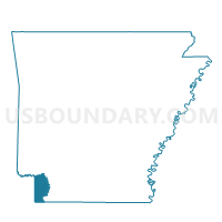
Central Precinct, Miller County, Arkansas
About
Outline

Summary
| Unique Area Identifier | 527285 |
| Name | Central Precinct |
| County | Miller County |
| State | Arkansas |
| Area (square miles) | 33.13 |
| Land Area (square miles) | 33.10 |
| Water Area (square miles) | 0.03 |
| % of Land Area | 99.91 |
| % of Water Area | 0.09 |
| Latitude of the Internal Point | 33.36119940 |
| Longtitude of the Internal Point | -93.84626140 |
Maps


Graphs
Select a template below for downloading or customizing gragh for Central Precinct, Miller County, Arkansas


Neighbors
Neighoring Voting District (by Name) Neighboring Voting District on the Map
- Boyd Precinct, Miller County, AR
- Fouke Precinct, Miller County, AR
- Garland Precinct, Miller County, AR
- Shiloh Precinct, Miller County, AR
Top 10 Neighboring County Subdivision (by Population) Neighboring County Subdivision on the Map
- Garland township, Miller County, AR (33,493)
- Beech township, Miller County, AR (3,773)
- Cleveland township, Miller County, AR (3,139)
- Red River township, Miller County, AR (307)
Top 10 Neighboring Unified School District (by Population) Neighboring Unified School District on the Map
- Fouke School District, AR (5,782)
- Lafayette County School District, AR (5,731)
- Genoa Central School District, AR (4,685)