


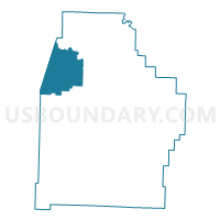
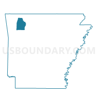
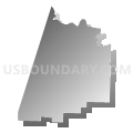
Prairie Voting District, Madison County, Arkansas
About
Outline

Summary
| Unique Area Identifier | 527227 |
| Name | Prairie Voting District |
| County | Madison County |
| State | Arkansas |
| Area (square miles) | 52.21 |
| Land Area (square miles) | 52.01 |
| Water Area (square miles) | 0.21 |
| % of Land Area | 99.61 |
| % of Water Area | 0.39 |
| Latitude of the Internal Point | 36.14025030 |
| Longtitude of the Internal Point | -93.87006900 |
Maps

Graphs
Select a template below for downloading or customizing gragh for Prairie Voting District, Madison County, Arkansas


Neighbors
Neighoring Voting District (by Name) Neighboring Voting District on the Map
- Bohannon Voting District, Madison County, AR
- BRUSH CREEK Voting District, Washington County, AR
- California Voting District, Madison County, AR
- GOSHEN TWP Voting District, Washington County, AR
- Lamar Voting District, Madison County, AR
- War Eagle 1 Voting District, Madison County, AR
Top 10 Neighboring County Subdivision (by Population) Neighboring County Subdivision on the Map
- War Eagle township, Madison County, AR (4,037)
- Brush Creek township, Washington County, AR (2,877)
- Goshen township, Washington County, AR (2,051)
- Prairie township, Madison County, AR (1,632)
- California township, Madison County, AR (1,303)
- Lamar township, Madison County, AR (949)
- Bohannan township, Madison County, AR (631)
Top 10 Neighboring Place (by Population) Neighboring Place on the Map
Top 10 Neighboring Unified School District (by Population) Neighboring Unified School District on the Map
- Springdale School District, AR (90,624)
- Fayetteville School District, AR (78,448)
- Huntsville School District, AR (14,572)
Top 10 Neighboring State Legislative District Lower Chamber (by Population) Neighboring State Legislative District Lower Chamber on the Map
Top 10 Neighboring State Legislative District Upper Chamber (by Population) Neighboring State Legislative District Upper Chamber on the Map
Top 10 Neighboring 111th Congressional District (by Population) Neighboring 111th Congressional District on the Map
Top 10 Neighboring Census Tract (by Population) Neighboring Census Tract on the Map
- Census Tract 101.05, Washington County, AR (8,065)
- Census Tract 101.02, Washington County, AR (7,647)
- Census Tract 9603, Madison County, AR (4,895)
- Census Tract 101.01, Washington County, AR (4,002)
- Census Tract 9601, Madison County, AR (3,878)
- Census Tract 9602, Madison County, AR (3,649)