


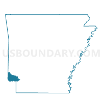
Jackson Voting District, Little River County, Arkansas
About
Outline

Summary
| Unique Area Identifier | 527125 |
| Name | Jackson Voting District |
| County | Little River County |
| State | Arkansas |
| Area (square miles) | 36.20 |
| Land Area (square miles) | 36.06 |
| Water Area (square miles) | 0.14 |
| % of Land Area | 99.62 |
| % of Water Area | 0.38 |
| Latitude of the Internal Point | 33.71781960 |
| Longtitude of the Internal Point | -94.41812760 |
Maps


Graphs
Select a template below for downloading or customizing gragh for Jackson Voting District, Little River County, Arkansas


Neighbors
Neighoring Voting District (by Name) Neighboring Voting District on the Map
- Voting District 12, McCurtain County, OK
- Arkinda Voting District, Little River County, AR
- Burke Voting District, Little River County, AR
- Foreman City 1 Voting District, Little River County, AR
- Foreman City 2 Voting District, Little River County, AR
- Foreman City 3 Voting District, Little River County, AR
- Little River Voting District, Little River County, AR
- Richland Voting District, Little River County, AR
- Wallace Voting District, Little River County, AR
Top 10 Neighboring County Subdivision (by Population) Neighboring County Subdivision on the Map
- Southeast McCurtain CCD, McCurtain County, OK (2,724)
- Jackson township, Little River County, AR (1,692)
- Wallace township, Little River County, AR (492)
- Burke township, Little River County, AR (297)
- Jeff Davis township, Little River County, AR (269)
- Arkinda township, Little River County, AR (75)
- Richland township, Little River County, AR (18)
Top 10 Neighboring Place (by Population) Neighboring Place on the Map
Top 10 Neighboring Unified School District (by Population) Neighboring Unified School District on the Map
- Ashdown School District, AR (9,717)
- Horatio School District, AR (4,045)
- Foreman School District, AR (2,782)
- Haworth Public Schools, OK (2,725)
Top 10 Neighboring State Legislative District Lower Chamber (by Population) Neighboring State Legislative District Lower Chamber on the Map
Top 10 Neighboring State Legislative District Upper Chamber (by Population) Neighboring State Legislative District Upper Chamber on the Map
Top 10 Neighboring 111th Congressional District (by Population) Neighboring 111th Congressional District on the Map
Top 10 Neighboring Census Tract (by Population) Neighboring Census Tract on the Map
- Census Tract 303, Little River County, AR (3,068)
- Census Tract 989, McCurtain County, OK (2,724)
- Census Tract 302, Little River County, AR (2,587)