


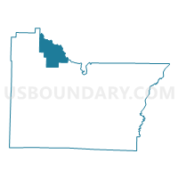
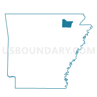
DENT Voting District, Lawrence County, Arkansas
About
Outline

Summary
| Unique Area Identifier | 527061 |
| Name | DENT Voting District |
| County | Lawrence County |
| State | Arkansas |
| Area (square miles) | 22.92 |
| Land Area (square miles) | 22.89 |
| Water Area (square miles) | 0.03 |
| % of Land Area | 99.86 |
| % of Water Area | 0.14 |
| Latitude of the Internal Point | 36.18004040 |
| Longtitude of the Internal Point | -91.19513860 |
Maps

Graphs
Select a template below for downloading or customizing gragh for DENT Voting District, Lawrence County, Arkansas


Neighbors
Neighoring Voting District (by Name) Neighboring Voting District on the Map
- ANNIEVILLE Voting District, Lawrence County, AR
- BLACK ROCK Voting District, Lawrence County, AR
- Butler Voting District, Randolph County, AR
- FLAT CREEK Voting District, Lawrence County, AR
- Jane's Creek Voting District, Randolph County, AR
- Spring River Voting District, Randolph County, AR
- SPRING RIVER Voting District, Lawrence County, AR
- THACKER Voting District, Lawrence County, AR
Top 10 Neighboring County Subdivision (by Population) Neighboring County Subdivision on the Map
- Black Rock township, Lawrence County, AR (1,285)
- Dent township, Lawrence County, AR (1,009)
- Janes Creek township, Randolph County, AR (702)
- Thacker township, Lawrence County, AR (453)
- Annieville township, Lawrence County, AR (409)
- Spring River township, Lawrence County, AR (374)
- Spring River township, Randolph County, AR (344)
- Flat Creek township, Lawrence County, AR (128)
- Butler township, Randolph County, AR (57)