


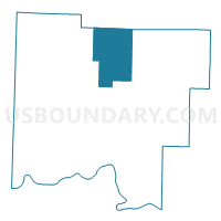
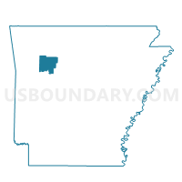
Sherman Voting District, Johnson County, Arkansas
About
Outline

Summary
| Unique Area Identifier | 526995 |
| Name | Sherman Voting District |
| County | Johnson County |
| State | Arkansas |
| Area (square miles) | 46.41 |
| Land Area (square miles) | 46.37 |
| Water Area (square miles) | 0.05 |
| % of Land Area | 99.90 |
| % of Water Area | 0.10 |
| Latitude of the Internal Point | 35.67597790 |
| Longtitude of the Internal Point | -93.42519310 |
Maps

Graphs
Select a template below for downloading or customizing gragh for Sherman Voting District, Johnson County, Arkansas


Neighbors
Neighoring Voting District (by Name) Neighboring Voting District on the Map
- Boston Voting District, Newton County, AR
- Low Gap Voting District, Johnson County, AR
- Mulberry Voting District, Johnson County, AR
- Perry Voting District, Johnson County, AR
- Red Lick Voting District, Johnson County, AR
Top 10 Neighboring County Subdivision (by Population) Neighboring County Subdivision on the Map
- Red Lick township, Johnson County, AR (1,232)
- Perry township, Johnson County, AR (787)
- Sherman township, Johnson County, AR (356)
- Jefferson township, Newton County, AR (284)
- Mulberry township, Johnson County, AR (170)
- Low Gap township, Johnson County, AR (136)
- Boston township, Newton County, AR (65)