


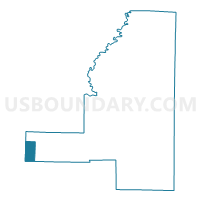
Denmark Voting District, Jackson County, Arkansas
About
Outline

Summary
| Unique Area Identifier | 526787 |
| Name | Denmark Voting District |
| County | Jackson County |
| State | Arkansas |
| Area (square miles) | 7.93 |
| Land Area (square miles) | 7.92 |
| Water Area (square miles) | 0.01 |
| % of Land Area | 99.83 |
| % of Water Area | 0.17 |
| Latitude of the Internal Point | 35.46985450 |
| Longtitude of the Internal Point | -91.56223720 |
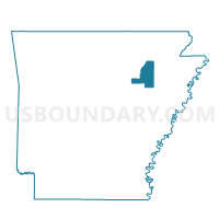
Maps

Graphs
Select a template below for downloading or customizing gragh for Denmark Voting District, Jackson County, Arkansas


Neighbors
Neighoring Voting District (by Name) Neighboring Voting District on the Map
- Crossroads Voting District, Jackson County, AR
- Denmark Voting District, White County, AR
- Liberty Voting District, Jackson County, AR
- Velvet Ridge Voting District, White County, AR
Top 10 Neighboring County Subdivision (by Population) Neighboring County Subdivision on the Map
- Velvet Ridge township, White County, AR (922)
- Barren township, Jackson County, AR (910)
- Denmark township, White County, AR (532)
Top 10 Neighboring Unified School District (by Population) Neighboring Unified School District on the Map
- Bald Knob School District, AR (7,315)
- Midland School District, AR (4,051)
- Bradford School District, AR (3,010)