


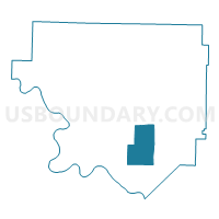
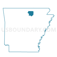
GID Voting District, Izard County, Arkansas
About
Outline

Summary
| Unique Area Identifier | 526746 |
| Name | GID Voting District |
| County | Izard County |
| State | Arkansas |
| Area (square miles) | 20.79 |
| Land Area (square miles) | 20.79 |
| Water Area (square miles) | 0.00 |
| % of Land Area | 100.00 |
| % of Water Area | 0.00 |
| Latitude of the Internal Point | 35.98426110 |
| Longtitude of the Internal Point | -91.85636830 |
Maps

Graphs
Select a template below for downloading or customizing gragh for GID Voting District, Izard County, Arkansas


Neighbors
Neighoring Voting District (by Name) Neighboring Voting District on the Map
- GUION RURAL Voting District, Izard County, AR
- LAFFERTY Voting District, Izard County, AR
- LUNERBURG Voting District, Izard County, AR
- MELBOURNE RURAL Voting District, Izard County, AR
- MT. PLEASANT RURAL Voting District, Izard County, AR
- SAGE Voting District, Izard County, AR
Top 10 Neighboring County Subdivision (by Population) Neighboring County Subdivision on the Map
- Mill Creek township, Izard County, AR (2,173)
- Sage township, Izard County, AR (315)
- Gid township, Izard County, AR (296)
- Drytown township, Izard County, AR (288)
- Lunenburg township, Izard County, AR (156)
- Guion township, Izard County, AR (113)
- Lafferty township, Izard County, AR (82)