


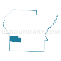
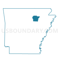
Relief Voting District, Independence County, Arkansas
About
Outline

Summary
| Unique Area Identifier | 526701 |
| Name | Relief Voting District |
| County | Independence County |
| State | Arkansas |
| Area (square miles) | 29.09 |
| Land Area (square miles) | 29.07 |
| Water Area (square miles) | 0.02 |
| % of Land Area | 99.95 |
| % of Water Area | 0.05 |
| Latitude of the Internal Point | 35.64680860 |
| Longtitude of the Internal Point | -91.72877020 |
Maps

Graphs
Select a template below for downloading or customizing gragh for Relief Voting District, Independence County, Arkansas


Neighbors
Neighoring Voting District (by Name) Neighboring Voting District on the Map
- Fairview Voting District, Independence County, AR
- Grassey Voting District, Cleburne County, AR
- Greenbrier TWP Voting District, Independence County, AR
- Huff Voting District, Independence County, AR
- Liberty Voting District, Independence County, AR
- Mchue Voting District, Independence County, AR
Top 10 Neighboring County Subdivision (by Population) Neighboring County Subdivision on the Map
- McHue township, Independence County, AR (3,683)
- Greenbrier township, Independence County, AR (1,807)
- Fairview township, Independence County, AR (1,544)
- Grassey township, Cleburne County, AR (1,184)
- Liberty township, Independence County, AR (813)
- Huff township, Independence County, AR (648)
- Relief township, Independence County, AR (474)
Top 10 Neighboring Unified School District (by Population) Neighboring Unified School District on the Map
- Batesville School District, AR (19,573)
- Southside School District, AR (5,368)
- Concord Public Schools, AR (4,463)
- Midland School District, AR (4,051)
Top 10 Neighboring State Legislative District Lower Chamber (by Population) Neighboring State Legislative District Lower Chamber on the Map
Top 10 Neighboring State Legislative District Upper Chamber (by Population) Neighboring State Legislative District Upper Chamber on the Map
Top 10 Neighboring 111th Congressional District (by Population) Neighboring 111th Congressional District on the Map
Top 10 Neighboring Census Tract (by Population) Neighboring Census Tract on the Map
- Census Tract 4907, Independence County, AR (6,879)
- Census Tract 4908, Independence County, AR (5,124)
- Census Tract 4801, Cleburne County, AR (4,298)