


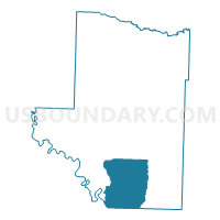
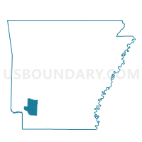
Springhill Voting District, Hempstead County, Arkansas
About
Outline

Summary
| Unique Area Identifier | 526599 |
| Name | Springhill Voting District |
| County | Hempstead County |
| State | Arkansas |
| Area (square miles) | 65.56 |
| Land Area (square miles) | 64.01 |
| Water Area (square miles) | 1.55 |
| % of Land Area | 97.63 |
| % of Water Area | 2.37 |
| Latitude of the Internal Point | 33.55105790 |
| Longtitude of the Internal Point | -93.66166860 |
Maps

Graphs
Select a template below for downloading or customizing gragh for Springhill Voting District, Hempstead County, Arkansas


Neighbors
Neighoring Voting District (by Name) Neighboring Voting District on the Map
- Bodcaw Voting District, Hempstead County, AR
- Bois Darc Voting District, Hempstead County, AR
- Boyd Hill Voting District, Lafayette County, AR
- DeRoan Voting District, Hempstead County, AR
- Garland Precinct, Miller County, AR
- Mandeville Voting District, Miller County, AR
- Piney Grove Voting District, Lafayette County, AR
- Watercreek Voting District, Hempstead County, AR
Top 10 Neighboring County Subdivision (by Population) Neighboring County Subdivision on the Map
- Garland township, Miller County, AR (33,493)
- De Roan township, Hempstead County, AR (13,406)
- Springhill township, Hempstead County, AR (1,520)
- Bois d'Arc township, Hempstead County, AR (690)
- La Grange township, Lafayette County, AR (550)
- Bodcaw township, Hempstead County, AR (511)
- Water Creek township, Hempstead County, AR (465)
- Red River township, Miller County, AR (307)
- Russell township, Lafayette County, AR (119)
Top 10 Neighboring Unified School District (by Population) Neighboring Unified School District on the Map
- Texarkana School District, AR (32,645)
- Hope School District, AR (15,849)
- Lafayette County School District, AR (5,731)
- Spring Hill School District, AR (1,487)
Top 10 Neighboring State Legislative District Lower Chamber (by Population) Neighboring State Legislative District Lower Chamber on the Map
- State House District 2, AR (25,839)
- State House District 3, AR (25,835)
- State House District 4, AR (25,193)
Top 10 Neighboring State Legislative District Upper Chamber (by Population) Neighboring State Legislative District Upper Chamber on the Map
Top 10 Neighboring 111th Congressional District (by Population) Neighboring 111th Congressional District on the Map
Top 10 Neighboring Census Tract (by Population) Neighboring Census Tract on the Map
- Census Tract 209, Miller County, AR (8,076)
- Census Tract 4701, Lafayette County, AR (4,728)
- Census Tract 4804, Hempstead County, AR (3,972)