


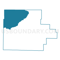
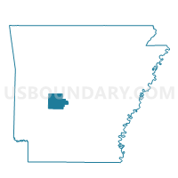
Baxter Voting District, Garland County, Arkansas
About
Outline

Summary
| Unique Area Identifier | 526507 |
| Name | Baxter Voting District |
| County | Garland County |
| State | Arkansas |
| Area (square miles) | 144.18 |
| Land Area (square miles) | 128.41 |
| Water Area (square miles) | 15.76 |
| % of Land Area | 89.07 |
| % of Water Area | 10.93 |
| Latitude of the Internal Point | 34.69157150 |
| Longtitude of the Internal Point | -93.27876410 |
Maps

Graphs
Select a template below for downloading or customizing gragh for Baxter Voting District, Garland County, Arkansas


Neighbors
Neighoring Voting District (by Name) Neighboring Voting District on the Map
- Crawford Voting District, Yell County, AR
- Fannie Voting District, Montgomery County, AR
- Jessieville Voting District, Garland County, AR
- Mt Ida Out Voting District, Montgomery County, AR
- Tyler Voting District, Perry County, AR
- Valley Voting District, Garland County, AR
Top 10 Neighboring County Subdivision (by Population) Neighboring County Subdivision on the Map
- Hale township, Garland County, AR (16,412)
- Mount Ida township, Montgomery County, AR (2,138)
- Fannie township, Montgomery County, AR (243)
- Tyler township, Perry County, AR (237)
- Crawford township, Yell County, AR (43)
Top 10 Neighboring Unified School District (by Population) Neighboring Unified School District on the Map
- Lake Hamilton School District, AR (23,990)
- Two Rivers School District, AR (7,182)
- Jessieville School District, AR (7,078)
- Perryville School District, AR (5,248)
- Mount Ida School District, AR (4,231)
- Mountain Pine School District, AR (4,121)
Top 10 Neighboring State Legislative District Lower Chamber (by Population) Neighboring State Legislative District Lower Chamber on the Map
- State House District 61, AR (29,993)
- State House District 30, AR (29,811)
- State House District 60, AR (28,463)
- State House District 22, AR (26,644)
- State House District 23, AR (26,178)
Top 10 Neighboring State Legislative District Upper Chamber (by Population) Neighboring State Legislative District Upper Chamber on the Map
- State Senate District 18, AR (85,656)
- State Senate District 4, AR (83,167)
- State Senate District 27, AR (81,170)
- State Senate District 19, AR (78,791)
Top 10 Neighboring 111th Congressional District (by Population) Neighboring 111th Congressional District on the Map
Top 10 Neighboring Census Tract (by Population) Neighboring Census Tract on the Map
- Census Tract 103, Garland County, AR (5,727)
- Census Tract 120.01, Garland County, AR (4,792)
- Census Tract 9530, Montgomery County, AR (3,299)
- Census Tract 9526, Yell County, AR (2,627)
- Census Tract 9529, Perry County, AR (1,810)