


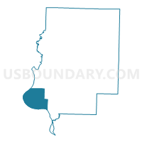
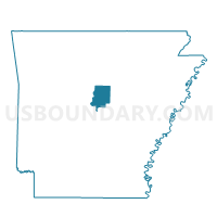
Benedict Voting District, Faulkner County, Arkansas
About
Outline

Summary
| Unique Area Identifier | 526434 |
| Name | Benedict Voting District |
| County | Faulkner County |
| State | Arkansas |
| Area (square miles) | 32.31 |
| Land Area (square miles) | 30.48 |
| Water Area (square miles) | 1.83 |
| % of Land Area | 94.34 |
| % of Water Area | 5.66 |
| Latitude of the Internal Point | 34.99027000 |
| Longtitude of the Internal Point | -92.53199480 |
Maps

Graphs
Select a template below for downloading or customizing gragh for Benedict Voting District, Faulkner County, Arkansas


Neighbors
Neighoring Voting District (by Name) Neighboring Voting District on the Map
- Voting District 57, Pulaski County, AR
- Danley Rural Voting District, Faulkner County, AR
- Perry Voting District, Perry County, AR
- Pine Mountain Voting District, Faulkner County, AR
- Union Voting District, Perry County, AR
- West Cadron Voting District, Faulkner County, AR
- Wye Voting District, Perry County, AR
Top 10 Neighboring County Subdivision (by Population) Neighboring County Subdivision on the Map
- Big Rock township, Pulaski County, AR (219,984)
- Cadron township, Faulkner County, AR (68,003)
- Danley township, Faulkner County, AR (4,694)
- Pine Mountain township, Faulkner County, AR (3,701)
- Benedict township, Faulkner County, AR (1,114)
- Union township, Perry County, AR (942)
- Wye township, Perry County, AR (935)
- Perry township, Perry County, AR (901)
Top 10 Neighboring Place (by Population) Neighboring Place on the Map
Top 10 Neighboring Unified School District (by Population) Neighboring Unified School District on the Map
- Pulaski County Special School District, AR (152,855)
- Conway Public Schools, AR (70,098)
- Mayflower School District, AR (6,142)
- East End School District, AR (4,020)
Top 10 Neighboring State Legislative District Lower Chamber (by Population) Neighboring State Legislative District Lower Chamber on the Map
- State House District 45, AR (32,959)
- State House District 42, AR (32,375)
- State House District 60, AR (28,463)
- State House District 38, AR (26,701)
Top 10 Neighboring State Legislative District Upper Chamber (by Population) Neighboring State Legislative District Upper Chamber on the Map
- State Senate District 22, AR (109,730)
- State Senate District 30, AR (103,943)
- State Senate District 18, AR (85,656)
Top 10 Neighboring 111th Congressional District (by Population) Neighboring 111th Congressional District on the Map
Top 10 Neighboring Census Tract (by Population) Neighboring Census Tract on the Map
- Census Tract 310.05, Faulkner County, AR (6,603)
- Census Tract 9527, Perry County, AR (5,282)
- Census Tract 311.02, Faulkner County, AR (5,109)
- Census Tract 42.01, Pulaski County, AR (2,552)
- Census Tract 310.03, Faulkner County, AR (2,269)