


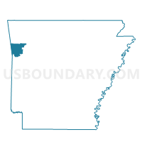
Chester Voting District, Crawford County, Arkansas
About
Outline

Summary
| Unique Area Identifier | 526308 |
| Name | Chester Voting District |
| County | Crawford County |
| State | Arkansas |
| Area (square miles) | 19.62 |
| Land Area (square miles) | 18.99 |
| Water Area (square miles) | 0.64 |
| % of Land Area | 96.75 |
| % of Water Area | 3.25 |
| Latitude of the Internal Point | 35.68766090 |
| Longtitude of the Internal Point | -94.18070790 |
Maps


Graphs
Select a template below for downloading or customizing gragh for Chester Voting District, Crawford County, Arkansas


Neighbors
Neighoring Voting District (by Name) Neighboring Voting District on the Map
- Cedar Creek Voting District, Crawford County, AR
- Locke Voting District, Crawford County, AR
- Mountain Voting District, Crawford County, AR
- Porter Voting District, Crawford County, AR
- Upper Voting District, Crawford County, AR
- Winfrey Voting District, Crawford County, AR
Top 10 Neighboring County Subdivision (by Population) Neighboring County Subdivision on the Map
- Chester township, Crawford County, AR (785)
- Cedar Creek township, Crawford County, AR (652)
- Porter township, Crawford County, AR (312)
- Locke township, Crawford County, AR (285)
- Upper township, Crawford County, AR (136)
- Winfrey township, Crawford County, AR (61)