


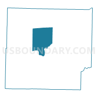
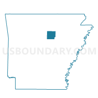
Francis Voting District, Cleburne County, Arkansas
About
Outline

Summary
| Unique Area Identifier | 526142 |
| Name | Francis Voting District |
| County | Cleburne County |
| State | Arkansas |
| Area (square miles) | 38.38 |
| Land Area (square miles) | 31.28 |
| Water Area (square miles) | 7.10 |
| % of Land Area | 81.49 |
| % of Water Area | 18.51 |
| Latitude of the Internal Point | 35.56628820 |
| Longtitude of the Internal Point | -92.05997430 |
Maps

Graphs
Select a template below for downloading or customizing gragh for Francis Voting District, Cleburne County, Arkansas


Neighbors
Neighoring Voting District (by Name) Neighboring Voting District on the Map
- California Voting District, Cleburne County, AR
- East Peter Creek Voting District, Cleburne County, AR
- Giles Voting District, Cleburne County, AR
- Healing Springs Voting District, Cleburne County, AR
- Heber Springs Out Voting District, Cleburne County, AR
- Sugar Camp Voting District, Cleburne County, AR
- Valley Voting District, Cleburne County, AR
- West Peter Creek Voting District, Cleburne County, AR
Top 10 Neighboring County Subdivision (by Population) Neighboring County Subdivision on the Map
- Heber township, Cleburne County, AR (9,772)
- Giles township, Cleburne County, AR (1,460)
- West Peter Creek township, Cleburne County, AR (1,038)
- Healing Springs township, Cleburne County, AR (975)
- Francis township, Cleburne County, AR (855)
- East Peter Creek township, Cleburne County, AR (716)
- Valley township, Cleburne County, AR (621)
- Sugar Camp township, Cleburne County, AR (427)
- California township, Cleburne County, AR (369)
Top 10 Neighboring Unified School District (by Population) Neighboring Unified School District on the Map
- Heber Springs School District, AR (11,984)
- West Side School District, AR (4,694)
- Concord Public Schools, AR (4,463)
Top 10 Neighboring State Legislative District Lower Chamber (by Population) Neighboring State Legislative District Lower Chamber on the Map
Top 10 Neighboring State Legislative District Upper Chamber (by Population) Neighboring State Legislative District Upper Chamber on the Map
Top 10 Neighboring 111th Congressional District (by Population) Neighboring 111th Congressional District on the Map
Top 10 Neighboring Census Tract (by Population) Neighboring Census Tract on the Map
- Census Tract 4803, Cleburne County, AR (5,293)
- Census Tract 4804, Cleburne County, AR (4,443)
- Census Tract 4802.02, Cleburne County, AR (3,769)
- Census Tract 4802.01, Cleburne County, AR (1,492)
Top 10 Neighboring 5-Digit ZIP Code Tabulation Area (by Population) Neighboring 5-Digit ZIP Code Tabulation Area on the Map
- 72543, AR (12,535)
- 72067, AR (2,726)
- 72530, AR (1,987)
- 72581, AR (1,030)
- 72044, AR (881)
- 72130, AR (560)