


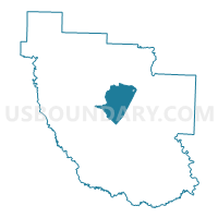
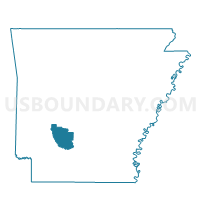
Central Voting District, Clark County, Arkansas
About
Outline

Summary
| Unique Area Identifier | 526103 |
| Name | Central Voting District |
| County | Clark County |
| State | Arkansas |
| Area (square miles) | 32.63 |
| Land Area (square miles) | 32.63 |
| Water Area (square miles) | 0.00 |
| % of Land Area | 100.00 |
| % of Water Area | 0.00 |
| Latitude of the Internal Point | 34.07909350 |
| Longtitude of the Internal Point | -93.16032500 |
Maps

Graphs
Select a template below for downloading or customizing gragh for Central Voting District, Clark County, Arkansas


Neighbors
Neighoring Voting District (by Name) Neighboring Voting District on the Map
- Arkadelphia JP 5, Clark County, AR
- Caddo Valley Outside Voting District, Clark County, AR
- Curtis Voting District, Clark County, AR
- Degray Voting District, Clark County, AR
- Gum Springs Outside Voting District, Clark County, AR
- Gurdon General Voting District, Clark County, AR
- Hollywood Voting District, Clark County, AR
- West County Voting District, Clark County, AR
Top 10 Neighboring County Subdivision (by Population) Neighboring County Subdivision on the Map
Top 10 Neighboring Place (by Population) Neighboring Place on the Map
Top 10 Neighboring Unified School District (by Population) Neighboring Unified School District on the Map
Top 10 Neighboring State Legislative District Lower Chamber (by Population) Neighboring State Legislative District Lower Chamber on the Map
Top 10 Neighboring State Legislative District Upper Chamber (by Population) Neighboring State Legislative District Upper Chamber on the Map
Top 10 Neighboring 111th Congressional District (by Population) Neighboring 111th Congressional District on the Map
Top 10 Neighboring Census Tract (by Population) Neighboring Census Tract on the Map
- Census Tract 9539, Clark County, AR (5,472)
- Census Tract 9536.02, Clark County, AR (4,443)
- Census Tract 9537, Clark County, AR (4,422)
- Census Tract 9538, Clark County, AR (4,008)