


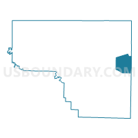
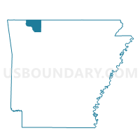
Coin Voting District, Carroll County, Arkansas
About
Outline

Summary
| Unique Area Identifier | 526054 |
| Name | Coin Voting District |
| County | Carroll County |
| State | Arkansas |
| Area (square miles) | 17.72 |
| Land Area (square miles) | 17.68 |
| Water Area (square miles) | 0.04 |
| % of Land Area | 99.80 |
| % of Water Area | 0.20 |
| Latitude of the Internal Point | 36.33178200 |
| Longtitude of the Internal Point | -93.32786050 |
Maps

Graphs
Select a template below for downloading or customizing gragh for Coin Voting District, Carroll County, Arkansas


Neighbors
Neighoring Voting District (by Name) Neighboring Voting District on the Map
- Carrollton Voting District, Boone County, AR
- Carrollton Voting District, Carroll County, AR
- Hickory NE Voting District, Carroll County, AR
- Long Creek Voting District, Carroll County, AR
- SE & SW Hickory Voting District, Carroll County, AR
Top 10 Neighboring County Subdivision (by Population) Neighboring County Subdivision on the Map
- Hickory township, Carroll County, AR (4,977)
- Carrollton township, Boone County, AR (843)
- Carrollton township, Carroll County, AR (716)
- Coin township, Carroll County, AR (655)
- Long Creek township, Carroll County, AR (614)
Top 10 Neighboring Place (by Population) Neighboring Place on the Map
Top 10 Neighboring Unified School District (by Population) Neighboring Unified School District on the Map
Top 10 Neighboring State Legislative District Lower Chamber (by Population) Neighboring State Legislative District Lower Chamber on the Map
Top 10 Neighboring State Legislative District Upper Chamber (by Population) Neighboring State Legislative District Upper Chamber on the Map
Top 10 Neighboring 111th Congressional District (by Population) Neighboring 111th Congressional District on the Map
Top 10 Neighboring Census Tract (by Population) Neighboring Census Tract on the Map
- Census Tract 9505, Carroll County, AR (7,470)
- Census Tract 7901, Boone County, AR (6,897)
- Census Tract 9504, Carroll County, AR (4,259)