


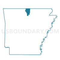
Voting District 11-8, Baxter County, Arkansas
About
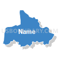
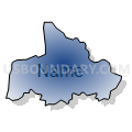
Outline

Summary
| Unique Area Identifier | 525880 |
| Name | Voting District 11-8 |
| County | Baxter County |
| State | Arkansas |
| Area (square miles) | 6.80 |
| Land Area (square miles) | 6.11 |
| Water Area (square miles) | 0.70 |
| % of Land Area | 89.78 |
| % of Water Area | 10.22 |
| Latitude of the Internal Point | 36.23898670 |
| Longtitude of the Internal Point | -92.21965200 |
Maps


Graphs
Select a template below for downloading or customizing gragh for Voting District 11-8, Baxter County, Arkansas


Neighbors
Neighoring Voting District (by Name) Neighboring Voting District on the Map
- Voting District 11-3, Baxter County, AR
- Voting District 11-9, Baxter County, AR
- Voting District 3-4, Baxter County, AR
- Voting District 9-2, Baxter County, AR
- Voting District 9-5, Baxter County, AR
Top 10 Neighboring County Subdivision (by Population) Neighboring County Subdivision on the Map
- Union township, Baxter County, AR (1,856)
- North Fork township, Baxter County, AR (1,574)
- Buckhorn township, Baxter County, AR (969)