


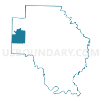
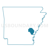
Barton Voting District, Arkansas County, Arkansas
About
Outline

Summary
| Unique Area Identifier | 525824 |
| Name | Barton Voting District |
| County | Arkansas County |
| State | Arkansas |
| Area (square miles) | 36.16 |
| Land Area (square miles) | 35.05 |
| Water Area (square miles) | 1.11 |
| % of Land Area | 96.93 |
| % of Water Area | 3.07 |
| Latitude of the Internal Point | 34.35403230 |
| Longtitude of the Internal Point | -91.66346250 |
Maps

Graphs
Select a template below for downloading or customizing gragh for Barton Voting District, Arkansas County, Arkansas


Neighbors
Neighoring Voting District (by Name) Neighboring Voting District on the Map
- 13 (Bogy) Voting District, Jefferson County, AR
- 19 (Dunnington) Voting District, Jefferson County, AR
- Brewer Voting District, Arkansas County, AR
- Garland Voting District, Arkansas County, AR
- Henton Voting District, Arkansas County, AR
- Morris Voting District, Arkansas County, AR
Top 10 Neighboring County Subdivision (by Population) Neighboring County Subdivision on the Map
- Morris township, Arkansas County, AR (702)
- Henton township, Arkansas County, AR (496)
- Dunnington township, Jefferson County, AR (344)
- Barton township, Arkansas County, AR (210)
- Garland township, Arkansas County, AR (134)
- Bogy township, Jefferson County, AR (80)
- Brewer township, Arkansas County, AR (50)
Top 10 Neighboring Unified School District (by Population) Neighboring Unified School District on the Map
- Stuttgart School District, AR (10,681)
- DeWitt School District, AR (8,785)
- Altheimer Unified School District, AR (4,343)