


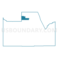
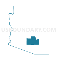
Schnepf N Voting District, Pinal County, Arizona
About
Outline

Summary
| Unique Area Identifier | 525618 |
| Name | Schnepf N Voting District |
| County | Pinal County |
| State | Arizona |
| Area (square miles) | 69.12 |
| Land Area (square miles) | 69.12 |
| Water Area (square miles) | 0.00 |
| % of Land Area | 100.00 |
| % of Water Area | 0.00 |
| Latitude of the Internal Point | 33.28964390 |
| Longtitude of the Internal Point | -111.48429510 |
Maps

Graphs
Select a template below for downloading or customizing gragh for Schnepf N Voting District, Pinal County, Arizona


Neighbors
Neighoring Voting District (by Name) Neighboring Voting District on the Map
- Apache Junction S Voting District, Pinal County, AZ
- MERIDIAN POINTE Voting District, Maricopa County, AZ
- Pecan Creek North Voting District, Pinal County, AZ
- Peralta Voting District, Pinal County, AZ
- Queen Creek Voting District, Pinal County, AZ
- Queen Valley Voting District, Pinal County, AZ
- RITTENHOUSE Voting District, Maricopa County, AZ
- Schnepf S Voting District, Pinal County, AZ
- SUNLAND SPRINGS Voting District, Maricopa County, AZ
- Superstition Mountain Voting District, Pinal County, AZ
Top 10 Neighboring County Subdivision (by Population) Neighboring County Subdivision on the Map
- Phoenix CCD, Maricopa County, AZ (2,972,357)
- Chandler CCD, Maricopa County, AZ (388,838)
- North Pinal CCD, Pinal County, AZ (152,330)
Top 10 Neighboring Place (by Population) Neighboring Place on the Map
- Mesa city, AZ (439,041)
- San Tan Valley CDP, AZ (81,321)
- Apache Junction city, AZ (35,840)
- Queen Creek town, AZ (26,361)
- Gold Canyon CDP, AZ (10,159)
- Queen Valley CDP, AZ (788)
Top 10 Neighboring Unified School District (by Population) Neighboring Unified School District on the Map
- Gilbert Unified District, AZ (184,433)
- Apache Junction Unified District, AZ (56,919)
- J. O. Combs Unified School District, AZ (34,868)
- Queen Creek Unified District, AZ (26,329)
- Superior Unified School District, AZ (3,364)
Top 10 Neighboring State Legislative District Lower Chamber (by Population) Neighboring State Legislative District Lower Chamber on the Map
- State House District 23, AZ (370,479)
- State House District 22, AZ (297,687)
- State House District 21, AZ (274,260)
Top 10 Neighboring State Legislative District Upper Chamber (by Population) Neighboring State Legislative District Upper Chamber on the Map
- State Senate District 23, AZ (370,479)
- State Senate District 22, AZ (297,687)
- State Senate District 21, AZ (274,260)
Top 10 Neighboring 111th Congressional District (by Population) Neighboring 111th Congressional District on the Map
Top 10 Neighboring Census Tract (by Population) Neighboring Census Tract on the Map
- Census Tract 2.05, Pinal County, AZ (15,769)
- Census Tract 2.07, Pinal County, AZ (11,032)
- Census Tract 4226.46, Maricopa County, AZ (7,730)
- Census Tract 4226.44, Maricopa County, AZ (7,287)
- Census Tract 2.04, Pinal County, AZ (6,610)
- Census Tract 2.01, Pinal County, AZ (5,469)
- Census Tract 2.06, Pinal County, AZ (3,742)
- Census Tract 8169, Maricopa County, AZ (3,393)
- Census Tract 23, Pinal County, AZ (2,420)
- Census Tract 3.19, Pinal County, AZ (1,352)
Top 10 Neighboring 5-Digit ZIP Code Tabulation Area (by Population) Neighboring 5-Digit ZIP Code Tabulation Area on the Map
- 85142, AZ (48,870)
- 85140, AZ (36,711)
- 85120, AZ (28,168)
- 85212, AZ (24,492)
- 85119, AZ (21,219)
- 85118, AZ (12,246)