


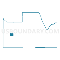
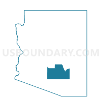
Stanfield Voting District, Pinal County, Arizona
About
Outline

Summary
| Unique Area Identifier | 525577 |
| Name | Stanfield Voting District |
| County | Pinal County |
| State | Arizona |
| Area (square miles) | 27.52 |
| Land Area (square miles) | 27.45 |
| Water Area (square miles) | 0.07 |
| % of Land Area | 99.75 |
| % of Water Area | 0.25 |
| Latitude of the Internal Point | 32.86335870 |
| Longtitude of the Internal Point | -111.93003340 |
Maps

Graphs
Select a template below for downloading or customizing gragh for Stanfield Voting District, Pinal County, Arizona


Neighbors
Neighoring Voting District (by Name) Neighboring Voting District on the Map
- Casa Grande SW Voting District, Pinal County, AZ
- Maricopa Voting District, Pinal County, AZ
- Tbird Farms Voting District, Pinal County, AZ