


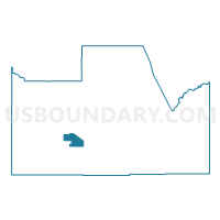
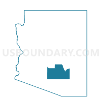
Toltec South Voting District, Pinal County, Arizona
About
Outline

Summary
| Unique Area Identifier | 525554 |
| Name | Toltec South Voting District |
| County | Pinal County |
| State | Arizona |
| Area (square miles) | 43.10 |
| Land Area (square miles) | 43.07 |
| Water Area (square miles) | 0.03 |
| % of Land Area | 99.94 |
| % of Water Area | 0.06 |
| Latitude of the Internal Point | 32.76487440 |
| Longtitude of the Internal Point | -111.64747750 |
Maps

Graphs
Select a template below for downloading or customizing gragh for Toltec South Voting District, Pinal County, Arizona


Neighbors
Neighoring Voting District (by Name) Neighboring Voting District on the Map
- Arizona City Voting District, Pinal County, AZ
- Casa Grande INT Voting District, Pinal County, AZ
- Casa Grande S Voting District, Pinal County, AZ
- Chui Chu Voting District, Pinal County, AZ
- Eloy Voting District, Pinal County, AZ
- Eloy South Voting District, Pinal County, AZ
- Picacho Voting District, Pinal County, AZ
- Toltec Voting District, Pinal County, AZ
Top 10 Neighboring County Subdivision (by Population) Neighboring County Subdivision on the Map
Top 10 Neighboring Place (by Population) Neighboring Place on the Map
Top 10 Neighboring Elementary School District (by Population) Neighboring Elementary School District on the Map
- Casa Grande Elementary District, AZ (60,768)
- Toltec Elementary District, AZ (14,196)
- Eloy Elementary District, AZ (6,642)
Top 10 Neighboring Secondary School District (by Population) Neighboring Secondary School District on the Map
- Casa Grande Union High School District, AZ (86,739)
- Santa Cruz Valley Union High School District, AZ (18,271)
Top 10 Neighboring State Legislative District Lower Chamber (by Population) Neighboring State Legislative District Lower Chamber on the Map
Top 10 Neighboring State Legislative District Upper Chamber (by Population) Neighboring State Legislative District Upper Chamber on the Map
Top 10 Neighboring 111th Congressional District (by Population) Neighboring 111th Congressional District on the Map
Top 10 Neighboring Census Tract (by Population) Neighboring Census Tract on the Map
- Census Tract 9414, Pinal County, AZ (8,497)
- Census Tract 21.01, Pinal County, AZ (7,966)
- Census Tract 21.03, Pinal County, AZ (5,143)
- Census Tract 20.01, Pinal County, AZ (3,519)
- Census Tract 19, Pinal County, AZ (2,571)
- Census Tract 21.02, Pinal County, AZ (1,320)