


Topock Voting District, Mohave County, Arizona
About
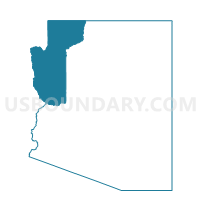
Outline

Summary
| Unique Area Identifier | 525055 |
| Name | Topock Voting District |
| County | Mohave County |
| State | Arizona |
| Area (square miles) | 52.17 |
| Land Area (square miles) | 45.84 |
| Water Area (square miles) | 6.32 |
| % of Land Area | 87.88 |
| % of Water Area | 12.12 |
| Latitude of the Internal Point | 34.77435380 |
| Longtitude of the Internal Point | -114.46963180 |
Maps


Graphs
Select a template below for downloading or customizing gragh for Topock Voting District, Mohave County, Arizona


Neighbors
Neighoring Voting District (by Name) Neighboring Voting District on the Map
- Voting District 11135, San Bernardino County, CA
- Voting District 11235, San Bernardino County, CA
- Voting District 11240, San Bernardino County, CA
- Bermuda City Voting District, Mohave County, AZ
- Desert Hills Voting District, Mohave County, AZ
- Hacienda Voting District, Mohave County, AZ
- Oatman Voting District, Mohave County, AZ
- Yucca Voting District, Mohave County, AZ
Top 10 Neighboring County Subdivision (by Population) Neighboring County Subdivision on the Map
- Bullhead City CCD, Mohave County, AZ (65,938)
- Lake Havasu City CCD, Mohave County, AZ (57,129)
- Needles CCD, San Bernardino County, CA (7,006)
Top 10 Neighboring Place (by Population) Neighboring Place on the Map
Top 10 Neighboring Elementary School District (by Population) Neighboring Elementary School District on the Map
Top 10 Neighboring Secondary School District (by Population) Neighboring Secondary School District on the Map
Top 10 Neighboring Unified School District (by Population) Neighboring Unified School District on the Map
Top 10 Neighboring State Legislative District Lower Chamber (by Population) Neighboring State Legislative District Lower Chamber on the Map
Top 10 Neighboring State Legislative District Upper Chamber (by Population) Neighboring State Legislative District Upper Chamber on the Map
Top 10 Neighboring 111th Congressional District (by Population) Neighboring 111th Congressional District on the Map
Top 10 Neighboring Census Tract (by Population) Neighboring Census Tract on the Map
- Census Tract 9520.02, Mohave County, AZ (7,439)
- Census Tract 9548, Mohave County, AZ (7,012)
- Census Tract 9550, Mohave County, AZ (5,286)
- Census Tract 9524, Mohave County, AZ (2,619)
- Census Tract 251, San Bernardino County, CA (1,688)