


CYPRESS Voting District, Maricopa County, Arizona
About
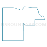
Outline

Summary
| Unique Area Identifier | 524996 |
| Name | CYPRESS Voting District |
| County | Maricopa County |
| State | Arizona |
| Area (square miles) | 1.29 |
| Land Area (square miles) | 1.29 |
| Water Area (square miles) | 0.00 |
| % of Land Area | 100.00 |
| % of Water Area | 0.00 |
| Latitude of the Internal Point | 33.47120490 |
| Longtitude of the Internal Point | -112.10860730 |
Maps


Graphs
Select a template below for downloading or customizing gragh for CYPRESS Voting District, Maricopa County, Arizona


Neighbors
Neighoring Voting District (by Name) Neighboring Voting District on the Map
- CAPITOL SCHOOL Voting District, Maricopa County, AZ
- ENCANTO Voting District, Maricopa County, AZ
- FLOWER Voting District, Maricopa County, AZ
- HAYDEN HIGH Voting District, Maricopa County, AZ
- ISAAC Voting District, Maricopa County, AZ
- MADRID Voting District, Maricopa County, AZ
- MULBERRY Voting District, Maricopa County, AZ
- WEST HIGH Voting District, Maricopa County, AZ
Top 10 Neighboring County Subdivision (by Population) Neighboring County Subdivision on the Map
Top 10 Neighboring Place (by Population) Neighboring Place on the Map
Top 10 Neighboring Elementary School District (by Population) Neighboring Elementary School District on the Map
- Alhambra Elementary District, AZ (84,491)
- Phoenix Elementary District, AZ (55,104)
- Isaac Elementary District, AZ (43,107)
- Osborn Elementary District, AZ (36,828)
Top 10 Neighboring Secondary School District (by Population) Neighboring Secondary School District on the Map
Top 10 Neighboring State Legislative District Lower Chamber (by Population) Neighboring State Legislative District Lower Chamber on the Map
Top 10 Neighboring State Legislative District Upper Chamber (by Population) Neighboring State Legislative District Upper Chamber on the Map
Top 10 Neighboring 111th Congressional District (by Population) Neighboring 111th Congressional District on the Map
Top 10 Neighboring Census Tract (by Population) Neighboring Census Tract on the Map
- Census Tract 1127, Maricopa County, AZ (6,740)
- Census Tract 1170, Maricopa County, AZ (5,678)
- Census Tract 1104, Maricopa County, AZ (5,125)
- Census Tract 1129, Maricopa County, AZ (4,805)
- Census Tract 1121, Maricopa County, AZ (3,838)
- Census Tract 1168, Maricopa County, AZ (2,655)
- Census Tract 1169, Maricopa County, AZ (2,387)
- Census Tract 1119, Maricopa County, AZ (2,238)