


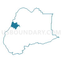
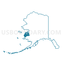
Nunam Iqua Precinct, Wade Hampton Census Area, Alaska
About
Outline

Summary
| Unique Area Identifier | 523550 |
| Name | Nunam Iqua Precinct |
| County | Wade Hampton Census Area |
| State | Alaska |
| Area (square miles) | 375.68 |
| Land Area (square miles) | 246.40 |
| Water Area (square miles) | 129.28 |
| % of Land Area | 65.59 |
| % of Water Area | 34.41 |
| Latitude of the Internal Point | 62.38029050 |
| Longtitude of the Internal Point | -164.92037170 |
Maps

Graphs
Select a template below for downloading or customizing gragh for Nunam Iqua Precinct, Wade Hampton Census Area, Alaska


Neighbors
Neighoring Voting District (by Name) Neighboring Voting District on the Map
- Alakanuk Precinct, Wade Hampton Census Area, AK
- Mountain Village Precinct, Wade Hampton Census Area, AK
- Scammon Bay Precinct, Wade Hampton Census Area, AK