


Copper Center Precinct, Valdez-Cordova Census Area, Alaska
About
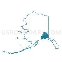
Outline

Summary
| Unique Area Identifier | 523540 |
| Name | Copper Center Precinct |
| County | Valdez-Cordova Census Area |
| State | Alaska |
| Area (square miles) | 9,987.21 |
| Land Area (square miles) | 9,742.68 |
| Water Area (square miles) | 244.53 |
| % of Land Area | 97.55 |
| % of Water Area | 2.45 |
| Latitude of the Internal Point | 61.27090720 |
| Longtitude of the Internal Point | -142.60551570 |
Maps


Graphs
Select a template below for downloading or customizing gragh for Copper Center Precinct, Valdez-Cordova Census Area, Alaska


Neighbors
Neighoring Voting District (by Name) Neighboring Voting District on the Map
- Chistochina Precinct, Valdez-Cordova Census Area, AK
- Gakona Precinct, Valdez-Cordova Census Area, AK
- Glennallen Precinct, Valdez-Cordova Census Area, AK
- Kenny Lake Precinct, Valdez-Cordova Census Area, AK
- Tatitlek Precinct (Part; Also See Part In Valdez-Cordova Census Area), Yakutat City and Borough, AK
- Tatitlek Precinct (Part; Also See Part In Yakutat Borough), Valdez-Cordova Census Area, AK
- Valdez No. 3 Precinct, Valdez-Cordova Census Area, AK
Top 10 Neighboring County Subdivision (by Population) Neighboring County Subdivision on the Map
- Chugach census subarea, Valdez-Cordova Census Area, AK (6,684)
- Copper River census subarea, Valdez-Cordova Census Area, AK (2,952)
- Yakutat census subarea, Yakutat City and Borough, AK (662)
Top 10 Neighboring Place (by Population) Neighboring Place on the Map
- Glennallen CDP, AK (483)
- Kenny Lake CDP, AK (355)
- Copper Center CDP, AK (328)
- Tazlina CDP, AK (297)
- Gakona CDP, AK (218)
- Willow Creek CDP, AK (191)
- Chitina CDP, AK (126)
- Gulkana CDP, AK (119)
- Silver Springs CDP, AK (114)
- McCarthy CDP, AK (28)
Top 10 Neighboring Unified School District (by Population) Neighboring Unified School District on the Map
- Copper River School District, AK (2,826)
- Yakutat City School District, AK (662)
- Chugach School District, AK (469)
Top 10 Neighboring State Legislative District Lower Chamber (by Population) Neighboring State Legislative District Lower Chamber on the Map
- State House District 12, Richardson-Glenn Highways, AK (14,811)
- State House District 6, Interior Villages, AK (14,235)
- State House District 5, Cordova-Southeast Islands, AK (13,846)
Top 10 Neighboring State Legislative District Upper Chamber (by Population) Neighboring State Legislative District Upper Chamber on the Map
Top 10 Neighboring 111th Congressional District (by Population) Neighboring 111th Congressional District on the Map
Top 10 Neighboring Census Tract (by Population) Neighboring Census Tract on the Map
- Census Tract 3, Valdez-Cordova Census Area, AK (4,420)
- Census Tract 1, Valdez-Cordova Census Area, AK (2,952)
- Census Tract 2, Valdez-Cordova Census Area, AK (2,264)
- Census Tract 1, Yakutat City and Borough, AK (662)