


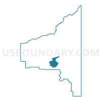
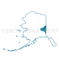
Tanacross Precinct, Southeast Fairbanks Census Area, Alaska
About
Outline

Summary
| Unique Area Identifier | 523525 |
| Name | Tanacross Precinct |
| County | Southeast Fairbanks Census Area |
| State | Alaska |
| Area (square miles) | 473.61 |
| Land Area (square miles) | 471.80 |
| Water Area (square miles) | 1.82 |
| % of Land Area | 99.62 |
| % of Water Area | 0.38 |
| Latitude of the Internal Point | 63.50700990 |
| Longtitude of the Internal Point | -143.65156130 |
Maps

Graphs
Select a template below for downloading or customizing gragh for Tanacross Precinct, Southeast Fairbanks Census Area, Alaska


Neighbors
Neighoring Voting District (by Name) Neighboring Voting District on the Map
- Dot Lake Precinct, Southeast Fairbanks Census Area, AK
- Eagle Precinct (Part; Also See Part In Yukon-Koyukuk Census Area), Southeast Fairbanks Census Area, AK
- Mentasta Precinct (Part; Also See Part In Valdez Cordova Census Area), Southeast Fairbanks Census Area, AK
- Tok Precinct (Part; Also See Part In Valdez-Cordova Census Area), Southeast Fairbanks Census Area, AK