


Wales Precinct, Nome Census Area, Alaska
About
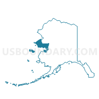
Outline

Summary
| Unique Area Identifier | 523478 |
| Name | Wales Precinct |
| County | Nome Census Area |
| State | Alaska |
| Area (square miles) | 1,192.26 |
| Land Area (square miles) | 975.66 |
| Water Area (square miles) | 216.60 |
| % of Land Area | 81.83 |
| % of Water Area | 18.17 |
| Latitude of the Internal Point | 65.67163620 |
| Longtitude of the Internal Point | -166.92142760 |
Maps


Graphs
Select a template below for downloading or customizing gragh for Wales Precinct, Nome Census Area, Alaska


Neighbors
Neighoring Voting District (by Name) Neighboring Voting District on the Map
- Brevig Mission Precinct, Nome Census Area, AK
- Shishmaref Precinct, Nome Census Area, AK
- Teller Precinct, Nome Census Area, AK