


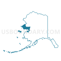
Elim Precinct, Nome Census Area, Alaska
About
Outline

Summary
| Unique Area Identifier | 523476 |
| Name | Elim Precinct |
| County | Nome Census Area |
| State | Alaska |
| Area (square miles) | 463.11 |
| Land Area (square miles) | 163.46 |
| Water Area (square miles) | 299.65 |
| % of Land Area | 35.30 |
| % of Water Area | 64.70 |
| Latitude of the Internal Point | 64.69742220 |
| Longtitude of the Internal Point | -162.01186010 |
Maps


Graphs
Select a template below for downloading or customizing gragh for Elim Precinct, Nome Census Area, Alaska


Neighbors
Neighoring Voting District (by Name) Neighboring Voting District on the Map
- Golovin Precinct, Nome Census Area, AK
- Koyuk Precinct, Nome Census Area, AK
- Shaktoolik Precinct, Nome Census Area, AK