


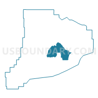
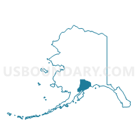
Ninilchik Precinct, Kenai Peninsula Borough, Alaska
About
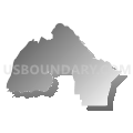
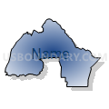
Outline

Summary
| Unique Area Identifier | 523402 |
| Name | Ninilchik Precinct |
| County | Kenai Peninsula Borough |
| State | Alaska |
| Area (square miles) | 1,241.56 |
| Land Area (square miles) | 1,125.71 |
| Water Area (square miles) | 115.84 |
| % of Land Area | 90.67 |
| % of Water Area | 9.33 |
| Latitude of the Internal Point | 59.96449680 |
| Longtitude of the Internal Point | -150.72915820 |
Maps

Graphs
Select a template below for downloading or customizing gragh for Ninilchik Precinct, Kenai Peninsula Borough, Alaska


Neighbors
Neighoring Voting District (by Name) Neighboring Voting District on the Map
- Anchor Point Precinct, Kenai Peninsula Borough, AK
- Bear Creek Precinct, Kenai Peninsula Borough, AK
- Funny River Precinct, Kenai Peninsula Borough, AK
- Kachemak Bay Precinct, Kenai Peninsula Borough, AK
- Kasilof Precinct, Kenai Peninsula Borough, AK
- Katchemak City/Fritz Creek Precinct, Kenai Peninsula Borough, AK
Top 10 Neighboring County Subdivision (by Population) Neighboring County Subdivision on the Map
- Kenai-Cook Inlet census subarea, Kenai Peninsula Borough, AK (49,733)
- Seward-Hope census subarea, Kenai Peninsula Borough, AK (5,667)
Top 10 Neighboring Place (by Population) Neighboring Place on the Map
- Fritz Creek CDP, AK (1,932)
- Anchor Point CDP, AK (1,930)
- Cohoe CDP, AK (1,364)
- Ninilchik CDP, AK (883)
- Fox River CDP, AK (685)
- Happy Valley CDP, AK (593)
- Nikolaevsk CDP, AK (318)
- Clam Gulch CDP, AK (176)
Top 10 Neighboring Unified School District (by Population) Neighboring Unified School District on the Map
Top 10 Neighboring State Legislative District Lower Chamber (by Population) Neighboring State Legislative District Lower Chamber on the Map
- State House District 34, Rural Kenai, AK (18,909)
- State House District 35, Homer-Seward, AK (17,419)
Top 10 Neighboring State Legislative District Upper Chamber (by Population) Neighboring State Legislative District Upper Chamber on the Map
Top 10 Neighboring 111th Congressional District (by Population) Neighboring 111th Congressional District on the Map
Top 10 Neighboring Census Tract (by Population) Neighboring Census Tract on the Map
- Census Tract 7, Kenai Peninsula Borough, AK (9,939)
- Census Tract 4, Kenai Peninsula Borough, AK (6,497)
- Census Tract 13, Kenai Peninsula Borough, AK (4,772)
- Census Tract 8, Kenai Peninsula Borough, AK (3,724)
- Census Tract 11, Kenai Peninsula Borough, AK (3,089)
- Census Tract 12, Kenai Peninsula Borough, AK (966)
Top 10 Neighboring 5-Digit ZIP Code Tabulation Area (by Population) Neighboring 5-Digit ZIP Code Tabulation Area on the Map
- 99669, AK (14,191)
- 99603, AK (9,840)
- 99664, AK (4,932)
- 99556, AK (2,510)
- 99610, AK (2,167)
- 99639, AK (1,131)
- 99568, AK (279)