


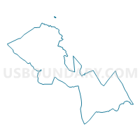
Klukwan Precinct, Hoonah-Angoon Census Area, Alaska
About
Outline

Summary
| Unique Area Identifier | 523357 |
| Name | Klukwan Precinct |
| County | Hoonah-Angoon Census Area |
| State | Alaska |
| Area (square miles) | 1.89 |
| Land Area (square miles) | 1.39 |
| Water Area (square miles) | 0.50 |
| % of Land Area | 73.45 |
| % of Water Area | 26.55 |
| Latitude of the Internal Point | 59.39816200 |
| Longtitude of the Internal Point | -135.88950650 |
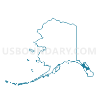
Maps

Graphs
Select a template below for downloading or customizing gragh for Klukwan Precinct, Hoonah-Angoon Census Area, Alaska


Neighbors
Neighoring Voting District (by Name) Neighboring Voting District on the Map
Top 10 Neighboring County Subdivision (by Population) Neighboring County Subdivision on the Map
- Haines census subarea, Haines Borough, AK (2,508)
- Klukwan census subarea, Hoonah-Angoon Census Area, AK (95)