


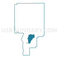
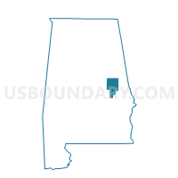
Sardis Community Bldg, Tallapoosa County, Alabama
About
Outline

Summary
| Unique Area Identifier | 522981 |
| Name | Sardis Community Bldg |
| County | Tallapoosa County |
| State | Alabama |
| Area (square miles) | 23.29 |
| Land Area (square miles) | 22.75 |
| Water Area (square miles) | 0.55 |
| % of Land Area | 97.65 |
| % of Water Area | 2.35 |
| Latitude of the Internal Point | 32.70045860 |
| Longtitude of the Internal Point | -85.77794700 |
Maps

Graphs
Select a template below for downloading or customizing gragh for Sardis Community Bldg, Tallapoosa County, Alabama


Neighbors
Neighoring Voting District (by Name) Neighboring Voting District on the Map
- Churchhill Voting House, Tallapoosa County, AL
- Mary's Cross Road Voting House, Tallapoosa County, AL
- New Paces Point Vol. Fire 902, Tallapoosa County, AL
- New Paces Point Vol. Fire Dept 901, Tallapoosa County, AL
- Reeltown Vol Fire Department, Tallapoosa County, AL
- Union Community Building, Tallapoosa County, AL
Top 10 Neighboring County Subdivision (by Population) Neighboring County Subdivision on the Map
Top 10 Neighboring Unified School District (by Population) Neighboring Unified School District on the Map
Top 10 Neighboring State Legislative District Lower Chamber (by Population) Neighboring State Legislative District Lower Chamber on the Map
Top 10 Neighboring State Legislative District Upper Chamber (by Population) Neighboring State Legislative District Upper Chamber on the Map
Top 10 Neighboring 111th Congressional District (by Population) Neighboring 111th Congressional District on the Map
Top 10 Neighboring Census Tract (by Population) Neighboring Census Tract on the Map
- Census Tract 9627, Tallapoosa County, AL (6,166)
- Census Tract 9625.02, Tallapoosa County, AL (2,950)