


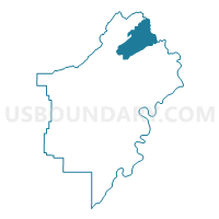
Steele Community Center Voting District, St. Clair County, Alabama
About
Outline

Summary
| Unique Area Identifier | 522863 |
| Name | Steele Community Center Voting District |
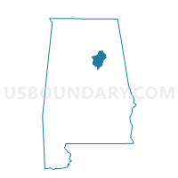
| County | St. Clair County |
| State | Alabama |
| Area (square miles) | 32.56 |
| Land Area (square miles) | 32.36 |
| Water Area (square miles) | 0.20 |
| % of Land Area | 99.39 |
| % of Water Area | 0.61 |
| Latitude of the Internal Point | 33.88821570 |
| Longtitude of the Internal Point | -86.21905460 |
Maps

Graphs
Select a template below for downloading or customizing gragh for Steele Community Center Voting District, St. Clair County, Alabama


Neighbors
Neighoring Voting District (by Name) Neighboring Voting District on the Map
- Ash Civic Center/Friendship Fire Dept. Voting District, St. Clair County, AL
- Attalla Recreation Center, Etowah County, AL
- Chandler Mt.Comm/Gallant Fire Dept./Slate Union Voting District, St. Clair County, AL
- Poplar Springs/Gum Springs Church/Oldham Chapel Voting District, St. Clair County, AL
- Rainbow City Community Center, Etowah County, AL
Top 10 Neighboring County Subdivision (by Population) Neighboring County Subdivision on the Map
Top 10 Neighboring Place (by Population) Neighboring Place on the Map
Top 10 Neighboring Unified School District (by Population) Neighboring Unified School District on the Map
Top 10 Neighboring State Legislative District Lower Chamber (by Population) Neighboring State Legislative District Lower Chamber on the Map
Top 10 Neighboring State Legislative District Upper Chamber (by Population) Neighboring State Legislative District Upper Chamber on the Map
Top 10 Neighboring 111th Congressional District (by Population) Neighboring 111th Congressional District on the Map
Top 10 Neighboring Census Tract (by Population) Neighboring Census Tract on the Map
- Census Tract 104.02, Etowah County, AL (5,504)
- Census Tract 404.01, St. Clair County, AL (4,731)
- Census Tract 404.02, St. Clair County, AL (3,718)
- Census Tract 103, Etowah County, AL (2,918)