


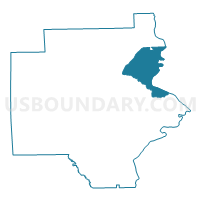
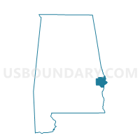
Spencer Recreation Center-B, Russell County, Alabama
About
Outline

Summary
| Unique Area Identifier | 522853 |
| Name | Spencer Recreation Center-B |
| County | Russell County |
| State | Alabama |
| Area (square miles) | 33.92 |
| Land Area (square miles) | 33.65 |
| Water Area (square miles) | 0.27 |
| % of Land Area | 99.21 |
| % of Water Area | 0.79 |
| Latitude of the Internal Point | 32.38542870 |
| Longtitude of the Internal Point | -85.02222910 |
Maps

Graphs
Select a template below for downloading or customizing gragh for Spencer Recreation Center-B, Russell County, Alabama


Neighbors
Neighoring Voting District (by Name) Neighboring Voting District on the Map
- 053FTBEN2 - FORT BENNING2 Voting District, Chattahoochee County, GA
- 053FTBEN3 - FORT BENNING3 Voting District, Chattahoochee County, GA
- 21540 - KEY ELEMENTARY Voting District, Muscogee County, GA
- Austin Sumbry Park Voting District, Russell County, AL
- Claude Parkman Building Voting District, Russell County, AL
- Crawford Fire Dept, Russell County, AL
- CVCC Voting District, Russell County, AL
- Fort Mitchell Community Center Voting District, Russell County, AL
Top 10 Neighboring County Subdivision (by Population) Neighboring County Subdivision on the Map
- Columbus West CCD, Muscogee County, GA (68,199)
- Phenix City CCD, Russell County, AL (43,357)
- Fort Benning CCD, Chattahoochee County, GA (8,306)
- Cottonton-Seale CCD, Russell County, AL (3,990)
- Crawford CCD, Russell County, AL (3,727)
Top 10 Neighboring Place (by Population) Neighboring Place on the Map
- Columbus city, GA (189,885)
- Phenix City city, AL (32,822)
- Cusseta-Chattahoochee County unified government, GA (11,267)
Top 10 Neighboring Elementary School District (by Population) Neighboring Elementary School District on the Map
Top 10 Neighboring Secondary School District (by Population) Neighboring Secondary School District on the Map
Top 10 Neighboring Unified School District (by Population) Neighboring Unified School District on the Map
- Muscogee County School District, GA (182,089)
- Phenix City City School District, AL (32,822)
- Russell County School District, AL (24,278)
Top 10 Neighboring State Legislative District Lower Chamber (by Population) Neighboring State Legislative District Lower Chamber on the Map
- State House District 80, AL (54,900)
- State House District 132, GA (42,799)
- State House District 148, GA (41,718)
- State House District 84, AL (41,317)
- State House District 83, AL (41,039)
Top 10 Neighboring State Legislative District Upper Chamber (by Population) Neighboring State Legislative District Upper Chamber on the Map
- State Senate District 27, AL (139,166)
- State Senate District 15, GA (133,879)
- State Senate District 28, AL (131,368)
Top 10 Neighboring 111th Congressional District (by Population) Neighboring 111th Congressional District on the Map
Top 10 Neighboring Census Tract (by Population) Neighboring Census Tract on the Map
- Census Tract 309.01, Russell County, AL (7,031)
- Census Tract 309.02, Russell County, AL (6,946)
- Census Tract 306, Russell County, AL (6,672)
- Census Tract 115, Muscogee County, GA (5,496)
- Census Tract 312, Russell County, AL (3,990)
- Census Tract 310, Russell County, AL (3,727)
- Census Tract 308, Russell County, AL (3,110)
- Census Tract 202.03, Chattahoochee County, GA (1,141)