


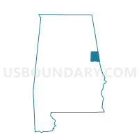
Ophelia, Randolph County, Alabama
About
Outline

Summary
| Unique Area Identifier | 522840 |
| Name | Ophelia |
| County | Randolph County |
| State | Alabama |
| Area (square miles) | 16.98 |
| Land Area (square miles) | 16.90 |
| Water Area (square miles) | 0.08 |
| % of Land Area | 99.56 |
| % of Water Area | 0.44 |
| Latitude of the Internal Point | 33.30511220 |
| Longtitude of the Internal Point | -85.62544290 |
Maps

Graphs
Select a template below for downloading or customizing gragh for Ophelia, Randolph County, Alabama


Neighbors
Neighoring Voting District (by Name) Neighboring Voting District on the Map
- Barfield Volunteer Fire Dept., Clay County, AL
- Cavers Grove, Swagg, Randolph County, AL
- Lineville National Guard Voting District, Clay County, AL
- Midwaym New Hope,Wedowee, Randolph County, AL
- Wadley, Randolph County, AL
- Wesley Chapel, Randolph County, AL
Top 10 Neighboring County Subdivision (by Population) Neighboring County Subdivision on the Map
- Lineville CCD, Clay County, AL (5,324)
- Wedowee CCD, Randolph County, AL (4,266)
- Folsom CCD, Randolph County, AL (3,615)
Top 10 Neighboring Unified School District (by Population) Neighboring Unified School District on the Map
Top 10 Neighboring State Legislative District Lower Chamber (by Population) Neighboring State Legislative District Lower Chamber on the Map
Top 10 Neighboring State Legislative District Upper Chamber (by Population) Neighboring State Legislative District Upper Chamber on the Map
Top 10 Neighboring 111th Congressional District (by Population) Neighboring 111th Congressional District on the Map
Top 10 Neighboring Census Tract (by Population) Neighboring Census Tract on the Map
- Census Tract 9589, Clay County, AL (5,324)
- Census Tract 3, Randolph County, AL (4,266)
- Census Tract 1, Randolph County, AL (3,615)