


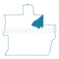
Ebernezer County Bldg, Pike County, Alabama
About
Outline

Summary
| Unique Area Identifier | 522812 |
| Name | Ebernezer County Bldg |
| County | Pike County |
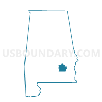
| State | Alabama |
| Area (square miles) | 31.86 |
| Land Area (square miles) | 31.85 |
| Water Area (square miles) | 0.00 |
| % of Land Area | 99.99 |
| % of Water Area | 0.01 |
| Latitude of the Internal Point | 31.89730170 |
| Longtitude of the Internal Point | -85.83326980 |
Maps

Graphs
Select a template below for downloading or customizing gragh for Ebernezer County Bldg, Pike County, Alabama


Neighbors
Neighoring Voting District (by Name) Neighboring Voting District on the Map
- Banks City Hall, Pike County, AL
- Corinth, Bullock County, AL
- Inverness, Bullock County, AL
- Josie-County Bldg, Pike County, AL
- Needsmore Childs Grocery, Pike County, AL
- Saco VFD, Pike County, AL
Top 10 Neighboring County Subdivision (by Population) Neighboring County Subdivision on the Map
- Troy CCD, Pike County, AL (20,070)
- Banks-Josie CCD, Pike County, AL (2,002)
- Needmore CCD, Pike County, AL (1,668)
- Inverness CCD, Bullock County, AL (1,628)
Top 10 Neighboring Unified School District (by Population) Neighboring Unified School District on the Map
Top 10 Neighboring State Legislative District Lower Chamber (by Population) Neighboring State Legislative District Lower Chamber on the Map
Top 10 Neighboring State Legislative District Upper Chamber (by Population) Neighboring State Legislative District Upper Chamber on the Map
Top 10 Neighboring 111th Congressional District (by Population) Neighboring 111th Congressional District on the Map
Top 10 Neighboring Census Tract (by Population) Neighboring Census Tract on the Map
- Census Tract 1889, Pike County, AL (4,994)
- Census Tract 9525, Bullock County, AL (2,378)
- Census Tract 1886, Pike County, AL (2,002)
- Census Tract 1887, Pike County, AL (1,668)