


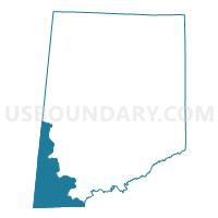
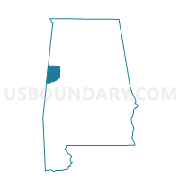
Cochrane-Dancy, Pickens County, Alabama
About
Outline

Summary
| Unique Area Identifier | 522788 |
| Name | Cochrane-Dancy |
| County | Pickens County |
| State | Alabama |
| Area (square miles) | 71.26 |
| Land Area (square miles) | 68.84 |
| Water Area (square miles) | 2.41 |
| % of Land Area | 96.61 |
| % of Water Area | 3.39 |
| Latitude of the Internal Point | 33.07900210 |
| Longtitude of the Internal Point | -88.27985620 |
Maps

Graphs
Select a template below for downloading or customizing gragh for Cochrane-Dancy, Pickens County, Alabama


Neighbors
Neighoring Voting District (by Name) Neighboring Voting District on the Map
- Aliceville 2 Nat'l Guard Armory, Pickens County, AL
- Cliftonville Voting District, Noxubee County, MS
- Panola Community Center, Sumter County, AL
- Pickensville City Hall, Pickens County, AL
- Prairie Point Voting District, Noxubee County, MS
- Savannah Voting District, Noxubee County, MS
- West Greene Fire Dept., Greene County, AL
Top 10 Neighboring County Subdivision (by Population) Neighboring County Subdivision on the Map
- Aliceville CCD, Pickens County, AL (5,384)
- District 1, Noxubee County, MS (2,382)
- District 2, Noxubee County, MS (2,283)
- Mantua-West Greene CCD, Greene County, AL (1,814)
- Panola-Geiger CCD, Sumter County, AL (927)
Top 10 Neighboring Place (by Population) Neighboring Place on the Map
Top 10 Neighboring Unified School District (by Population) Neighboring Unified School District on the Map
- Pickens County School District, AL (19,746)
- Sumter County School District, AL (13,763)
- Noxubee County School District, MS (11,545)
- Greene County School District, AL (9,045)
Top 10 Neighboring State Legislative District Lower Chamber (by Population) Neighboring State Legislative District Lower Chamber on the Map
- State House District 61, AL (41,422)
- State House District 71, AL (38,094)
- State House District 42, MS (20,974)
Top 10 Neighboring State Legislative District Upper Chamber (by Population) Neighboring State Legislative District Upper Chamber on the Map
- State Senate District 21, AL (140,682)
- State Senate District 24, AL (118,832)
- State Senate District 32, MS (49,900)
- State Senate District 16, MS (49,681)
Top 10 Neighboring 111th Congressional District (by Population) Neighboring 111th Congressional District on the Map
Top 10 Neighboring Census Tract (by Population) Neighboring Census Tract on the Map
- Census Tract 9501, Noxubee County, MS (5,446)
- Census Tract 504, Pickens County, AL (5,384)
- Census Tract 114, Sumter County, AL (1,850)
- Census Tract 600, Greene County, AL (1,814)
Top 10 Neighboring 5-Digit ZIP Code Tabulation Area (by Population) Neighboring 5-Digit ZIP Code Tabulation Area on the Map
- 39341, MS (7,156)
- 35462, AL (5,061)
- 35442, AL (4,972)
- 35447, AL (3,460)
- 39739, MS (2,957)
- 35459, AL (872)
- 35477, AL (335)