


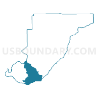
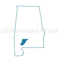
Uriah FD, Monroe County, Alabama
About
Outline

Summary
| Unique Area Identifier | 522639 |
| Name | Uriah FD |
| County | Monroe County |
| State | Alabama |
| Area (square miles) | 78.34 |
| Land Area (square miles) | 78.19 |
| Water Area (square miles) | 0.14 |
| % of Land Area | 99.82 |
| % of Water Area | 0.18 |
| Latitude of the Internal Point | 31.31723050 |
| Longtitude of the Internal Point | -87.52068370 |
Maps

Graphs
Select a template below for downloading or customizing gragh for Uriah FD, Monroe County, Alabama


Neighbors
Neighoring Voting District (by Name) Neighboring Voting District on the Map
- Chrysler/Eliska/McGill, Monroe County, AL
- Goodhope AME Church/0012 Alma Volunteer Fire Dept., Clarke County, AL
- Goodway FD, Monroe County, AL
- Goodway Fire Dept., Monroe County, AL
- Huxford-Masonic Lodge, Escambia County, AL
- McCullough Vol. Fire Dept., Escambia County, AL
- Megargel Assembly of God Voting District, Monroe County, AL
- Perdue Hill Masonic Lodge, Monroe County, AL
- Range Fire Dept., Conecuh County, AL
- Shiloh/Grimes, Monroe County, AL
Top 10 Neighboring County Subdivision (by Population) Neighboring County Subdivision on the Map
- Monroeville CCD, Monroe County, AL (9,865)
- Frisco City CCD, Monroe County, AL (6,681)
- McCullough-Huxford CCD, Escambia County, AL (5,744)
- Grove Hill CCD, Clarke County, AL (5,488)
- Uriah CCD, Monroe County, AL (1,814)
- Repton CCD, Conecuh County, AL (1,731)
Top 10 Neighboring Place (by Population) Neighboring Place on the Map
Top 10 Neighboring Unified School District (by Population) Neighboring Unified School District on the Map
- Escambia County School District, AL (32,911)
- Monroe County School District, AL (23,068)
- Clarke County School District, AL (19,941)
- Conecuh County School District, AL (13,228)
Top 10 Neighboring State Legislative District Lower Chamber (by Population) Neighboring State Legislative District Lower Chamber on the Map
Top 10 Neighboring State Legislative District Upper Chamber (by Population) Neighboring State Legislative District Upper Chamber on the Map
Top 10 Neighboring 111th Congressional District (by Population) Neighboring 111th Congressional District on the Map
- Congressional District 1, AL (687,841)
- Congressional District 2, AL (673,877)
- Congressional District 7, AL (603,352)
Top 10 Neighboring Census Tract (by Population) Neighboring Census Tract on the Map
- Census Tract 761, Monroe County, AL (6,681)
- Census Tract 759, Monroe County, AL (6,323)
- Census Tract 9704, Escambia County, AL (5,744)
- Census Tract 9578, Clarke County, AL (5,488)
- Census Tract 762, Monroe County, AL (1,814)
- Census Tract 9603, Conecuh County, AL (1,731)