


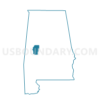
Sawyerville, Hale County, Alabama
About
Outline

Summary
| Unique Area Identifier | 521896 |
| Name | Sawyerville |
| County | Hale County |
| State | Alabama |
| Area (square miles) | 60.25 |
| Land Area (square miles) | 57.77 |
| Water Area (square miles) | 2.48 |
| % of Land Area | 95.88 |
| % of Water Area | 4.12 |
| Latitude of the Internal Point | 32.71844980 |
| Longtitude of the Internal Point | -87.76100120 |
Maps


Graphs
Select a template below for downloading or customizing gragh for Sawyerville, Hale County, Alabama


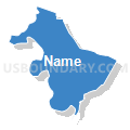


Neighbors
Neighoring Voting District (by Name) Neighboring Voting District on the Map
- Akron City Hall A, Hale County, AL
- Carver School, Greene County, AL
- Cedarville, Hale County, AL
- Dollarhide Rec Center, Greene County, AL
- Forkland City Hall, Greene County, AL
- National Guard Armory 1-A, Hale County, AL
- National Guard Armory 4-A, Hale County, AL
- Sawyerville B, Hale County, AL
- South Fork, Greene County, AL
Top 10 Neighboring County Subdivision (by Population) Neighboring County Subdivision on the Map
- Eutaw CCD, Greene County, AL (4,410)
- Sawyerville CCD, Hale County, AL (2,093)
- Forkland-Tishabee CCD, Greene County, AL (1,955)
- Greensboro South CCD, Hale County, AL (949)
Top 10 Neighboring Unified School District (by Population) Neighboring Unified School District on the Map
Top 10 Neighboring State Legislative District Lower Chamber (by Population) Neighboring State Legislative District Lower Chamber on the Map
Top 10 Neighboring State Legislative District Upper Chamber (by Population) Neighboring State Legislative District Upper Chamber on the Map
Top 10 Neighboring 111th Congressional District (by Population) Neighboring 111th Congressional District on the Map
Top 10 Neighboring Census Tract (by Population) Neighboring Census Tract on the Map
- Census Tract 404, Hale County, AL (5,399)
- Census Tract 601, Greene County, AL (4,410)
- Census Tract 602, Greene County, AL (2,821)
- Census Tract 403, Hale County, AL (2,093)
Top 10 Neighboring 5-Digit ZIP Code Tabulation Area (by Population) Neighboring 5-Digit ZIP Code Tabulation Area on the Map
- 36744, AL (7,419)
- 35462, AL (5,061)
- 35443, AL (2,009)
- 36776, AL (1,489)
- 36740, AL (1,328)
- 35441, AL (1,060)