


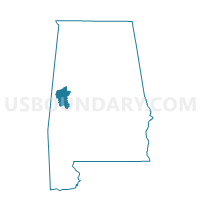
Tishabee Rec Center, Greene County, Alabama
About
Outline

Summary
| Unique Area Identifier | 521861 |
| Name | Tishabee Rec Center |
| County | Greene County |
| State | Alabama |
| Area (square miles) | 62.06 |
| Land Area (square miles) | 60.63 |
| Water Area (square miles) | 1.43 |
| % of Land Area | 97.69 |
| % of Water Area | 2.31 |
| Latitude of the Internal Point | 32.65755560 |
| Longtitude of the Internal Point | -87.97904730 |
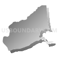
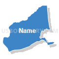
Maps


Graphs
Select a template below for downloading or customizing gragh for Tishabee Rec Center, Greene County, Alabama


Neighbors
Neighoring Voting District (by Name) Neighboring Voting District on the Map
- Boligee City Hall, Greene County, AL
- Coatopa Fire Dept, Sumter County, AL
- Dollarhide Rec Center, Greene County, AL
- Epes Community Center, Sumter County, AL
- Eutaw Activity center, Greene County, AL
- Forkland City Hall, Greene County, AL
- Livingston Community Center, Sumter County, AL
Top 10 Neighboring County Subdivision (by Population) Neighboring County Subdivision on the Map
- Livingston CCD, Sumter County, AL (5,764)
- Eutaw CCD, Greene County, AL (4,410)
- Forkland-Tishabee CCD, Greene County, AL (1,955)
- Boligee CCD, Greene County, AL (866)
- Belmont CCD, Sumter County, AL (487)
Top 10 Neighboring Unified School District (by Population) Neighboring Unified School District on the Map
Top 10 Neighboring State Legislative District Lower Chamber (by Population) Neighboring State Legislative District Lower Chamber on the Map
Top 10 Neighboring State Legislative District Upper Chamber (by Population) Neighboring State Legislative District Upper Chamber on the Map
Top 10 Neighboring 111th Congressional District (by Population) Neighboring 111th Congressional District on the Map
Top 10 Neighboring Census Tract (by Population) Neighboring Census Tract on the Map
- Census Tract 113, Sumter County, AL (6,251)
- Census Tract 601, Greene County, AL (4,410)
- Census Tract 602, Greene County, AL (2,821)