


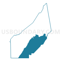
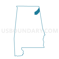
District Three, DeKalb County, Alabama
About
Outline

Summary
| Unique Area Identifier | 521679 |
| Name | District Three |
| County | DeKalb County |
| State | Alabama |
| Area (square miles) | 201.81 |
| Land Area (square miles) | 201.19 |
| Water Area (square miles) | 0.62 |
| % of Land Area | 99.69 |
| % of Water Area | 0.31 |
| Latitude of the Internal Point | 34.34426820 |
| Longtitude of the Internal Point | -85.78350980 |
Maps

Graphs
Select a template below for downloading or customizing gragh for District Three, DeKalb County, Alabama


Neighbors
Neighoring Voting District (by Name) Neighboring Voting District on the Map
- Black Creek Baptist Church, Etowah County, AL
- Dist. 3 Maintenance Shop, Etowah County, AL
- District Four, DeKalb County, AL
- District One, DeKalb County, AL
- District Two, DeKalb County, AL
- Duck Springs School, Etowah County, AL
- Friendship Baptist Church/Mt. Calvery Baptist Church, Cherokee County, AL
- Sand Rock Town Hall, Cherokee County, AL
- Tucker's Chapel VFW, Cherokee County, AL
- Valley Church, Cherokee County, AL
Top 10 Neighboring County Subdivision (by Population) Neighboring County Subdivision on the Map
- Fort Payne CCD, DeKalb County, AL (19,055)
- Mountainboro CCD, Etowah County, AL (9,378)
- Cedar Bluff-Gaylesville CCD, Cherokee County, AL (7,204)
- Leesburg CCD, Cherokee County, AL (5,561)
- Collinsville CCD, DeKalb County, AL (4,498)
- Valley Head-Mentone CCD, DeKalb County, AL (4,304)
- Lookout Mountain CCD, Etowah County, AL (2,953)
- Wills Valley CCD, Etowah County, AL (1,721)
Top 10 Neighboring Place (by Population) Neighboring Place on the Map
- Fort Payne city, AL (14,012)
- Collinsville town, AL (1,983)
- Sand Rock town, AL (560)
- Pine Ridge town, AL (282)
Top 10 Neighboring Unified School District (by Population) Neighboring Unified School District on the Map
- Etowah County School District, AL (60,417)
- DeKalb County School District, AL (57,097)
- Cherokee County School District, AL (25,989)
- Fort Payne City School District, AL (14,012)
Top 10 Neighboring State Legislative District Lower Chamber (by Population) Neighboring State Legislative District Lower Chamber on the Map
- State House District 24, AL (48,127)
- State House District 39, AL (46,905)
- State House District 29, AL (43,353)
Top 10 Neighboring State Legislative District Upper Chamber (by Population) Neighboring State Legislative District Upper Chamber on the Map
Top 10 Neighboring 111th Congressional District (by Population) Neighboring 111th Congressional District on the Map
Top 10 Neighboring Census Tract (by Population) Neighboring Census Tract on the Map
- Census Tract 9613, DeKalb County, AL (5,967)
- Census Tract 9558, Cherokee County, AL (5,561)
- Census Tract 110.01, Etowah County, AL (4,613)
- Census Tract 9608, DeKalb County, AL (4,498)
- Census Tract 9614, DeKalb County, AL (4,304)
- Census Tract 9610, DeKalb County, AL (3,914)
- Census Tract 9557.02, Cherokee County, AL (3,872)
- Census Tract 9609, DeKalb County, AL (3,809)
- Census Tract 9611, DeKalb County, AL (3,258)
- Census Tract 108, Etowah County, AL (2,953)
Top 10 Neighboring 5-Digit ZIP Code Tabulation Area (by Population) Neighboring 5-Digit ZIP Code Tabulation Area on the Map
- 35967, AL (16,630)
- 35954, AL (12,416)
- 35961, AL (6,514)
- 35959, AL (4,836)
- 35968, AL (4,575)
- 35983, AL (3,738)
- 35973, AL (2,870)
- 35984, AL (1,889)