


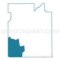
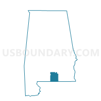
Wing Fire Dept.-Catoe's Store, Covington County, Alabama
About
Outline

Summary
| Unique Area Identifier | 521547 |
| Name | Wing Fire Dept.-Catoe's Store |
| County | Covington County |
| State | Alabama |
| Area (square miles) | 115.33 |
| Land Area (square miles) | 113.38 |
| Water Area (square miles) | 1.95 |
| % of Land Area | 98.31 |
| % of Water Area | 1.69 |
| Latitude of the Internal Point | 31.07915450 |
| Longtitude of the Internal Point | -86.62051240 |
Maps

Graphs
Select a template below for downloading or customizing gragh for Wing Fire Dept.-Catoe's Store, Covington County, Alabama


Neighbors
Neighoring Voting District (by Name) Neighboring Voting District on the Map
- 2A-Voting District (Blackmon), Okaloosa County, FL
- 5A-Voting District (Laurel Hill), Okaloosa County, FL
- Bradley -Rock Creek Vol. Fire Dept., Escambia County, AL
- Brooklyn Fire Dept., Conecuh County, AL
- Carolina City Hall, Covington County, AL
- Dixie Vol. Fire Dept., Escambia County, AL
- Fairfield-Shady Bend, Covington County, AL
- Lockhart-Damacus, Covington County, AL
- Stanley-Enon-McAdams, Covington County, AL
Top 10 Neighboring County Subdivision (by Population) Neighboring County Subdivision on the Map
- Andalusia CCD, Covington County, AL (18,495)
- Baker CCD, Okaloosa County, FL (7,688)
- East Escambia CCD, Escambia County, AL (5,955)
- Evergreen CCD, Conecuh County, AL (5,762)
- Florala CCD, Covington County, AL (3,684)
- Laurel Hill CCD, Okaloosa County, FL (1,921)
- Falco CCD, Covington County, AL (1,846)
Top 10 Neighboring Unified School District (by Population) Neighboring Unified School District on the Map
- Okaloosa County School District, FL (180,822)
- Escambia County School District, AL (32,911)
- Covington County School District, AL (22,091)
- Conecuh County School District, AL (13,228)
Top 10 Neighboring State Legislative District Lower Chamber (by Population) Neighboring State Legislative District Lower Chamber on the Map
- State House District 1, FL (159,402)
- State House District 5, FL (154,014)
- State House District 92, AL (40,506)
- State House District 90, AL (39,991)
Top 10 Neighboring State Legislative District Upper Chamber (by Population) Neighboring State Legislative District Upper Chamber on the Map
- State Senate District 2, FL (449,902)
- State Senate District 22, AL (137,373)
- State Senate District 31, AL (129,622)
Top 10 Neighboring 111th Congressional District (by Population) Neighboring 111th Congressional District on the Map
- Congressional District 1, FL (694,158)
- Congressional District 1, AL (687,841)
- Congressional District 2, AL (673,877)
Top 10 Neighboring Census Tract (by Population) Neighboring Census Tract on the Map
- Census Tract 201, Okaloosa County, FL (7,688)
- Census Tract 9698, Escambia County, AL (5,955)
- Census Tract 9606, Conecuh County, AL (4,667)
- Census Tract 9617, Covington County, AL (4,032)
- Census Tract 9630, Covington County, AL (3,684)
- Census Tract 202, Okaloosa County, FL (1,921)
- Census Tract 9629, Covington County, AL (1,846)
Top 10 Neighboring 5-Digit ZIP Code Tabulation Area (by Population) Neighboring 5-Digit ZIP Code Tabulation Area on the Map
- 36420, AL (10,673)
- 36421, AL (9,241)
- 32531, FL (5,296)
- 36442, AL (3,555)
- 32567, FL (3,510)
- 36483, AL (536)