


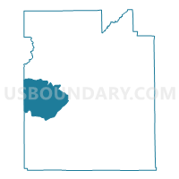
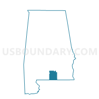
Fairfield-Shady Bend, Covington County, Alabama
About
Outline

Summary
| Unique Area Identifier | 521541 |
| Name | Fairfield-Shady Bend |
| County | Covington County |
| State | Alabama |
| Area (square miles) | 68.79 |
| Land Area (square miles) | 68.19 |
| Water Area (square miles) | 0.60 |
| % of Land Area | 99.12 |
| % of Water Area | 0.88 |
| Latitude of the Internal Point | 31.23984120 |
| Longtitude of the Internal Point | -86.63123830 |
Maps

Graphs
Select a template below for downloading or customizing gragh for Fairfield-Shady Bend, Covington County, Alabama


Neighbors
Neighoring Voting District (by Name) Neighboring Voting District on the Map
- Andalusia, Covington County, AL
- Brooklyn Fire Dept., Conecuh County, AL
- Carolina City Hall, Covington County, AL
- Dixie Vol. Fire Dept., Escambia County, AL
- Loango, Covington County, AL
- Paul Fire Dept., Conecuh County, AL
- River Falls City Hall, Covington County, AL
- Wing Fire Dept.-Catoe's Store, Covington County, AL
Top 10 Neighboring County Subdivision (by Population) Neighboring County Subdivision on the Map
- Andalusia CCD, Covington County, AL (18,495)
- East Escambia CCD, Escambia County, AL (5,955)
- Evergreen CCD, Conecuh County, AL (5,762)
- Falco CCD, Covington County, AL (1,846)
Top 10 Neighboring Place (by Population) Neighboring Place on the Map
Top 10 Neighboring Unified School District (by Population) Neighboring Unified School District on the Map
- Escambia County School District, AL (32,911)
- Covington County School District, AL (22,091)
- Conecuh County School District, AL (13,228)
Top 10 Neighboring State Legislative District Lower Chamber (by Population) Neighboring State Legislative District Lower Chamber on the Map
Top 10 Neighboring State Legislative District Upper Chamber (by Population) Neighboring State Legislative District Upper Chamber on the Map
Top 10 Neighboring 111th Congressional District (by Population) Neighboring 111th Congressional District on the Map
Top 10 Neighboring Census Tract (by Population) Neighboring Census Tract on the Map
- Census Tract 9698, Escambia County, AL (5,955)
- Census Tract 9606, Conecuh County, AL (4,667)
- Census Tract 9617, Covington County, AL (4,032)
- Census Tract 9618, Covington County, AL (3,129)
- Census Tract 9629, Covington County, AL (1,846)