


Locust Shores, Colbert County, Alabama
About
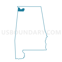
Outline

Summary
| Unique Area Identifier | 521476 |
| Name | Locust Shores |
| County | Colbert County |
| State | Alabama |
| Area (square miles) | 23.11 |
| Land Area (square miles) | 21.42 |
| Water Area (square miles) | 1.69 |
| % of Land Area | 92.67 |
| % of Water Area | 7.33 |
| Latitude of the Internal Point | 34.70311200 |
| Longtitude of the Internal Point | -87.80145690 |
Maps


Graphs
Select a template below for downloading or customizing gragh for Locust Shores, Colbert County, Alabama


Neighbors
Neighoring Voting District (by Name) Neighboring Voting District on the Map
- Barton, Colbert County, AL
- Colbert Heights, Colbert County, AL
- New Bethel Fire Dept., Colbert County, AL
- Oakland Fire Station, Lauderdale County, AL
- Tuscumbia, Colbert County, AL
Top 10 Neighboring County Subdivision (by Population) Neighboring County Subdivision on the Map
- Tri-Cities CCD, Colbert County, AL (33,934)
- Littleville CCD, Colbert County, AL (8,299)
- Oakland CCD, Lauderdale County, AL (4,023)
Top 10 Neighboring Unified School District (by Population) Neighboring Unified School District on the Map
Top 10 Neighboring State Legislative District Lower Chamber (by Population) Neighboring State Legislative District Lower Chamber on the Map
- State House District 1, AL (47,247)
- State House District 18, AL (43,784)
- State House District 3, AL (42,348)
Top 10 Neighboring State Legislative District Upper Chamber (by Population) Neighboring State Legislative District Upper Chamber on the Map
Top 10 Neighboring 111th Congressional District (by Population) Neighboring 111th Congressional District on the Map
Top 10 Neighboring Census Tract (by Population) Neighboring Census Tract on the Map
- Census Tract 205, Colbert County, AL (5,221)
- Census Tract 112, Lauderdale County, AL (4,023)
- Census Tract 209.02, Colbert County, AL (3,972)