


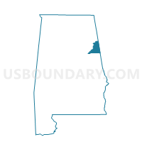
Borden Springs, Cleburne County, Alabama
About
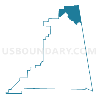
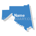
Outline

Summary
| Unique Area Identifier | 521425 |
| Name | Borden Springs |
| County | Cleburne County |
| State | Alabama |
| Area (square miles) | 35.22 |
| Land Area (square miles) | 35.18 |
| Water Area (square miles) | 0.04 |
| % of Land Area | 99.89 |
| % of Water Area | 0.11 |
| Latitude of the Internal Point | 33.92598030 |
| Longtitude of the Internal Point | -85.44338290 |
Maps

Graphs
Select a template below for downloading or customizing gragh for Borden Springs, Cleburne County, Alabama


Neighbors
Neighoring Voting District (by Name) Neighboring Voting District on the Map
- 14308 - LITTLE CREEK Voting District, Haralson County, GA
- 23306 - ESOM HILL Voting District, Polk County, GA
- Bethel United Methodist Church, Calhoun County, AL
- Oak Level, Cleburne County, AL
- Spring Garden Volunteer Fire Dept., Cherokee County, AL
Top 10 Neighboring County Subdivision (by Population) Neighboring County Subdivision on the Map
- Cedartown CCD, Polk County, GA (24,695)
- Tallapoosa CCD, Haralson County, GA (8,189)
- Piedmont CCD, Calhoun County, AL (7,495)
- Spring Garden CCD, Cherokee County, AL (4,972)
- Fruithurst CCD, Cleburne County, AL (2,684)
Top 10 Neighboring Place (by Population) Neighboring Place on the Map
Top 10 Neighboring Unified School District (by Population) Neighboring Unified School District on the Map
- Polk County School District, GA (41,475)
- Cherokee County School District, AL (25,989)
- Haralson County School District, GA (22,598)
- Cleburne County School District, AL (14,610)
- Piedmont City School District, AL (6,677)
Top 10 Neighboring State Legislative District Lower Chamber (by Population) Neighboring State Legislative District Lower Chamber on the Map
- State House District 18, GA (52,188)
- State House District 40, AL (49,653)
- State House District 16, GA (49,562)
- State House District 39, AL (46,905)
Top 10 Neighboring State Legislative District Upper Chamber (by Population) Neighboring State Legislative District Upper Chamber on the Map
- State Senate District 31, GA (204,694)
- State Senate District 12, AL (142,431)
- State Senate District 13, AL (132,777)
Top 10 Neighboring 111th Congressional District (by Population) Neighboring 111th Congressional District on the Map
Top 10 Neighboring Census Tract (by Population) Neighboring Census Tract on the Map
- Census Tract 102, Haralson County, GA (5,725)
- Census Tract 9561, Cherokee County, AL (4,972)
- Census Tract 103, Polk County, GA (4,809)
- Census Tract 22, Calhoun County, AL (3,652)
- Census Tract 9595, Cleburne County, AL (2,684)