


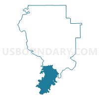
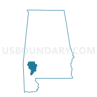
Saltworks Voting House, Clarke County, Alabama
About
Outline

Summary
| Unique Area Identifier | 521384 |
| Name | Saltworks Voting House |
| County | Clarke County |
| State | Alabama |
| Area (square miles) | 128.53 |
| Land Area (square miles) | 122.36 |
| Water Area (square miles) | 6.16 |
| % of Land Area | 95.20 |
| % of Water Area | 4.80 |
| Latitude of the Internal Point | 31.31255740 |
| Longtitude of the Internal Point | -87.85511100 |
Maps

Graphs
Select a template below for downloading or customizing gragh for Saltworks Voting House, Clarke County, Alabama


Neighbors
Neighoring Voting District (by Name) Neighboring Voting District on the Map
- Carson/Preswick, Washington County, AL
- Chrysler/Eliska/McGill, Monroe County, AL
- Cortelyou, Washington County, AL
- Goodhope AME Church/0012 Alma Volunteer Fire Dept., Clarke County, AL
- Jackson City Hall, Clarke County, AL
- Little River Ferguson Store, Baldwin County, AL
- Malcolm Voting House Voting District, Washington County, AL
- McIntosh Community Center Voting District, Washington County, AL
- Tensaw Volunteer Fire Dept, Baldwin County, AL
Top 10 Neighboring County Subdivision (by Population) Neighboring County Subdivision on the Map
- Jackson CCD, Clarke County, AL (7,723)
- McIntosh CCD, Washington County, AL (4,589)
- Stockton CCD, Baldwin County, AL (3,804)
- Wagarville CCD, Washington County, AL (3,353)
- Walker Springs CCD, Clarke County, AL (3,020)
- Uriah CCD, Monroe County, AL (1,814)
Top 10 Neighboring Place (by Population) Neighboring Place on the Map
Top 10 Neighboring Unified School District (by Population) Neighboring Unified School District on the Map
- Baldwin County School District, AL (182,265)
- Monroe County School District, AL (23,068)
- Clarke County School District, AL (19,941)
- Washington County School District, AL (17,581)
Top 10 Neighboring State Legislative District Lower Chamber (by Population) Neighboring State Legislative District Lower Chamber on the Map
- State House District 64, AL (40,427)
- State House District 65, AL (38,681)
- State House District 68, AL (36,234)
Top 10 Neighboring State Legislative District Upper Chamber (by Population) Neighboring State Legislative District Upper Chamber on the Map
Top 10 Neighboring 111th Congressional District (by Population) Neighboring 111th Congressional District on the Map
Top 10 Neighboring Census Tract (by Population) Neighboring Census Tract on the Map
- Census Tract 442, Washington County, AL (4,589)
- Census Tract 9579.02, Clarke County, AL (4,230)
- Census Tract 101, Baldwin County, AL (3,804)
- Census Tract 441, Washington County, AL (3,353)
- Census Tract 762, Monroe County, AL (1,814)
- Census Tract 9580.02, Clarke County, AL (1,731)
Top 10 Neighboring 5-Digit ZIP Code Tabulation Area (by Population) Neighboring 5-Digit ZIP Code Tabulation Area on the Map
- 36545, AL (9,941)
- 36553, AL (3,575)
- 36480, AL (1,773)
- 36513, AL (555)
- 36556, AL (308)
- 36581, AL (224)