


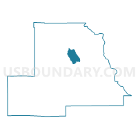
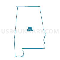
Collins Chapel Fire Station, Chilton County, Alabama
About
Outline

Summary
| Unique Area Identifier | 521355 |
| Name | Collins Chapel Fire Station |
| County | Chilton County |
| State | Alabama |
| Area (square miles) | 9.49 |
| Land Area (square miles) | 9.44 |
| Water Area (square miles) | 0.05 |
| % of Land Area | 99.51 |
| % of Water Area | 0.49 |
| Latitude of the Internal Point | 32.92828430 |
| Longtitude of the Internal Point | -86.68081180 |
Maps

Graphs
Select a template below for downloading or customizing gragh for Collins Chapel Fire Station, Chilton County, Alabama


Neighbors
Neighoring Voting District (by Name) Neighboring Voting District on the Map
- Cane Creek Fire Station, Chilton County, AL
- City of Jemison, Chilton County, AL
- Clanton Facility Bldg., Chilton County, AL
- Thorsby Town Hall, Chilton County, AL
- Union Grove Fire Station, Chilton County, AL
Top 10 Neighboring County Subdivision (by Population) Neighboring County Subdivision on the Map
- Clanton CCD, Chilton County, AL (14,329)
- Jemison CCD, Chilton County, AL (14,242)
- Mineral Springs CCD, Chilton County, AL (3,808)
Top 10 Neighboring Place (by Population) Neighboring Place on the Map
Top 10 Neighboring Unified School District (by Population) Neighboring Unified School District on the Map
Top 10 Neighboring State Legislative District Lower Chamber (by Population) Neighboring State Legislative District Lower Chamber on the Map
Top 10 Neighboring State Legislative District Upper Chamber (by Population) Neighboring State Legislative District Upper Chamber on the Map
Top 10 Neighboring 111th Congressional District (by Population) Neighboring 111th Congressional District on the Map
Top 10 Neighboring Census Tract (by Population) Neighboring Census Tract on the Map
- Census Tract 601.02, Chilton County, AL (6,303)
- Census Tract 604.01, Chilton County, AL (5,466)
- Census Tract 603, Chilton County, AL (3,808)
- Census Tract 602, Chilton County, AL (2,807)