


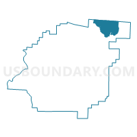
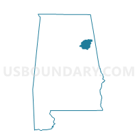
Piedmont, Calhoun County, Alabama
About
Outline

Summary
| Unique Area Identifier | 521301 |
| Name | Piedmont |
| County | Calhoun County |
| State | Alabama |
| Area (square miles) | 22.79 |
| Land Area (square miles) | 22.63 |
| Water Area (square miles) | 0.16 |
| % of Land Area | 99.30 |
| % of Water Area | 0.70 |
| Latitude of the Internal Point | 33.93750980 |
| Longtitude of the Internal Point | -85.64613420 |
Maps

Graphs
Select a template below for downloading or customizing gragh for Piedmont, Calhoun County, Alabama


Neighbors
Neighoring Voting District (by Name) Neighboring Voting District on the Map
- Asberry Baptist Church, Calhoun County, AL
- Bethel United Methodist Church, Calhoun County, AL
- Goshen United Methodist Church, Cherokee County, AL
- Mt. Weisner Volunteer Fire Dept./Melrose Baptist Church, Cherokee County, AL
- Spring Garden Volunteer Fire Dept., Cherokee County, AL
- White Plains Fire Dept.Voting District, Calhoun County, AL
Top 10 Neighboring County Subdivision (by Population) Neighboring County Subdivision on the Map
- Jacksonville CCD, Calhoun County, AL (18,722)
- Centre CCD, Cherokee County, AL (8,252)
- Piedmont CCD, Calhoun County, AL (7,495)
Top 10 Neighboring Place (by Population) Neighboring Place on the Map
Top 10 Neighboring Unified School District (by Population) Neighboring Unified School District on the Map
- Calhoun County School District, AL (57,392)
- Cherokee County School District, AL (25,989)
- Piedmont City School District, AL (6,677)
Top 10 Neighboring State Legislative District Lower Chamber (by Population) Neighboring State Legislative District Lower Chamber on the Map
Top 10 Neighboring State Legislative District Upper Chamber (by Population) Neighboring State Legislative District Upper Chamber on the Map
- State Senate District 12, AL (142,431)
- State Senate District 13, AL (132,777)
- State Senate District 10, AL (125,075)
Top 10 Neighboring 111th Congressional District (by Population) Neighboring 111th Congressional District on the Map
Top 10 Neighboring Census Tract (by Population) Neighboring Census Tract on the Map
- Census Tract 24, Calhoun County, AL (4,518)
- Census Tract 9559, Cherokee County, AL (4,235)
- Census Tract 23, Calhoun County, AL (3,843)
- Census Tract 22, Calhoun County, AL (3,652)