


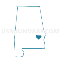
Aberfoil, Bullock County, Alabama
About
Outline

Summary
| Unique Area Identifier | 521269 |
| Name | Aberfoil |
| County | Bullock County |
| State | Alabama |
| Area (square miles) | 35.73 |
| Land Area (square miles) | 35.60 |
| Water Area (square miles) | 0.13 |
| % of Land Area | 99.65 |
| % of Water Area | 0.35 |
| Latitude of the Internal Point | 32.00746790 |
| Longtitude of the Internal Point | -85.71941720 |
Maps

Graphs
Select a template below for downloading or customizing gragh for Aberfoil, Bullock County, Alabama


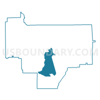
Neighbors
Neighoring Voting District (by Name) Neighboring Voting District on the Map
- Corinth, Bullock County, AL
- Indian Creek, Bullock County, AL
- Inverness, Bullock County, AL
- Perote, Bullock County, AL
- Sardis, Bullock County, AL
- Union Springs Armory, Bullock County, AL