


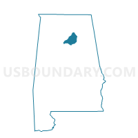
Mt. High, Blount County, Alabama
About
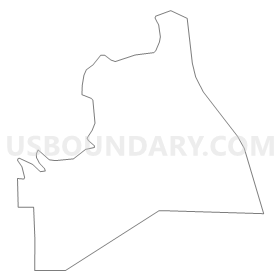
Outline
Summary
| Unique Area Identifier | 521234 |
| Name | Mt. High |
| County | Blount County |
| State | Alabama |
| Area (square miles) | 32.43 |
| Land Area (square miles) | 32.29 |
| Water Area (square miles) | 0.14 |
| % of Land Area | 99.58 |
| % of Water Area | 0.42 |
| Latitude of the Internal Point | 33.87022430 |
| Longtitude of the Internal Point | -86.89335750 |
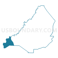
Maps

Graphs
Select a template below for downloading or customizing gragh for Mt. High, Blount County, Alabama


Neighbors
Neighoring Voting District (by Name) Neighboring Voting District on the Map
- Arkedelphia Community Center, Cullman County, AL
- Blount Springs, Blount County, AL
- Colony Town Hall, Cullman County, AL
- Corner School, Jefferson County, AL
- Empire Union Bldg, Walker County, AL
- Smoke Rise, Blount County, AL
- Warrior City Hall, Jefferson County, AL
Top 10 Neighboring County Subdivision (by Population) Neighboring County Subdivision on the Map
- Hayden CCD, Blount County, AL (12,844)
- Bremen CCD, Cullman County, AL (8,283)
- Warrior CCD, Jefferson County, AL (6,581)
- Empire CCD, Walker County, AL (2,493)
Top 10 Neighboring Place (by Population) Neighboring Place on the Map
Top 10 Neighboring Unified School District (by Population) Neighboring Unified School District on the Map
- Jefferson County School District, AL (230,679)
- Cullman County School District, AL (65,702)
- Walker County School District, AL (52,671)
- Blount County School District, AL (50,755)
Top 10 Neighboring State Legislative District Lower Chamber (by Population) Neighboring State Legislative District Lower Chamber on the Map
- State House District 34, AL (50,560)
- State House District 51, AL (48,552)
- State House District 12, AL (45,798)
- State House District 13, AL (39,882)
Top 10 Neighboring State Legislative District Upper Chamber (by Population) Neighboring State Legislative District Upper Chamber on the Map
- State Senate District 17, AL (157,178)
- State Senate District 5, AL (134,976)
- State Senate District 4, AL (123,291)
Top 10 Neighboring 111th Congressional District (by Population) Neighboring 111th Congressional District on the Map
Top 10 Neighboring Census Tract (by Population) Neighboring Census Tract on the Map
- Census Tract 114, Jefferson County, AL (6,581)
- Census Tract 9655, Cullman County, AL (5,631)
- Census Tract 506.01, Blount County, AL (3,922)
- Census Tract 9657, Cullman County, AL (2,652)
- Census Tract 219, Walker County, AL (2,493)