


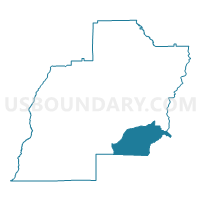
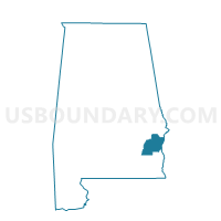
White Oak Methodist Church, Barbour County, Alabama
About
Outline

Summary
| Unique Area Identifier | 521214 |
| Name | White Oak Methodist Church |
| County | Barbour County |
| State | Alabama |
| Area (square miles) | 54.78 |
| Land Area (square miles) | 53.78 |
| Water Area (square miles) | 1.00 |
| % of Land Area | 98.18 |
| % of Water Area | 1.82 |
| Latitude of the Internal Point | 31.75011630 |
| Longtitude of the Internal Point | -85.24962380 |
Maps

Graphs
Select a template below for downloading or customizing gragh for White Oak Methodist Church, Barbour County, Alabama


Neighbors
Neighoring Voting District (by Name) Neighboring Voting District on the Map
- 0615 - DAY'S CROSS ROAD Voting District, Clay County, GA
- 239G - GEORGETOWN Voting District, Quitman County, GA
- Baker Hill Town Hall, Barbour County, AL
- Bevill Center/Chatthoochee Cts Com Ctr/Eufaula Com Ctr/Eufaula WB/Fellowship BC/Sanford AG, Barbour County, AL
- Edwin Clubhouse, Henry County, AL
- Judson Com., Henry County, AL
- Lawrenceville, Henry County, AL
Top 10 Neighboring County Subdivision (by Population) Neighboring County Subdivision on the Map
- Abbeville CCD, Henry County, AL (4,872)
- Bakerhill CCD, Barbour County, AL (3,467)
- Shorterville CCD, Henry County, AL (3,093)
- Fort Gaines CCD, Clay County, GA (2,322)
- Georgetown South CCD, Quitman County, GA (1,189)
Top 10 Neighboring Place (by Population) Neighboring Place on the Map
- Eufaula city, AL (13,137)
- Georgetown-Quitman County unified government, GA (2,513)
- Bakerhill town, AL (279)
Top 10 Neighboring Unified School District (by Population) Neighboring Unified School District on the Map
- Henry County School District, AL (17,297)
- Barbour County School District, AL (14,320)
- Eufaula City School District, AL (13,137)
- Clay County School District, GA (3,183)
- Quitman County School District, GA (2,513)
Top 10 Neighboring State Legislative District Lower Chamber (by Population) Neighboring State Legislative District Lower Chamber on the Map
- State House District 149, GA (43,458)
- State House District 85, AL (42,429)
- State House District 148, GA (41,718)
- State House District 84, AL (41,317)
Top 10 Neighboring State Legislative District Upper Chamber (by Population) Neighboring State Legislative District Upper Chamber on the Map
Top 10 Neighboring 111th Congressional District (by Population) Neighboring 111th Congressional District on the Map
Top 10 Neighboring Census Tract (by Population) Neighboring Census Tract on the Map
- Census Tract 9505, Barbour County, AL (3,467)
- Census Tract 9603, Clay County, GA (3,183)
- Census Tract 303, Henry County, AL (3,093)
- Census Tract 9603, Quitman County, GA (2,513)
- Census Tract 301, Henry County, AL (1,910)