


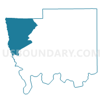
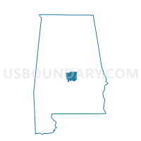
Jones Community Center, Autauga County, Alabama
About
Outline

Summary
| Unique Area Identifier | 521146 |
| Name | Jones Community Center |
| County | Autauga County |
| State | Alabama |
| Area (square miles) | 78.26 |
| Land Area (square miles) | 77.73 |
| Water Area (square miles) | 0.53 |
| % of Land Area | 99.32 |
| % of Water Area | 0.68 |
| Latitude of the Internal Point | 32.58483200 |
| Longtitude of the Internal Point | -86.84746500 |
Maps

Graphs
Select a template below for downloading or customizing gragh for Jones Community Center, Autauga County, Alabama


Neighbors
Neighoring Voting District (by Name) Neighboring Voting District on the Map
- Billingsley Government Center, Autauga County, AL
- Independence Voting Center, Autauga County, AL
- Mt. Zion Church, Dallas County, AL
- Mulberry/Statesville, Autauga County, AL
- Plantersville VFD, Dallas County, AL
- So. Chilton Fire Station, Chilton County, AL
- Valley Grande VFD, Dallas County, AL
Top 10 Neighboring County Subdivision (by Population) Neighboring County Subdivision on the Map
- Selma CCD, Dallas County, AL (32,439)
- Autaugaville CCD, Autauga County, AL (3,320)
- Isabella-Pletcher CCD, Chilton County, AL (3,261)
- Maplesville CCD, Chilton County, AL (2,902)
- Billingsley CCD, Autauga County, AL (2,894)
Top 10 Neighboring Unified School District (by Population) Neighboring Unified School District on the Map
- Autauga County School District, AL (54,571)
- Chilton County School District, AL (43,643)
- Dallas County School District, AL (23,064)
Top 10 Neighboring State Legislative District Lower Chamber (by Population) Neighboring State Legislative District Lower Chamber on the Map
- State House District 42, AL (48,338)
- State House District 67, AL (37,878)
- State House District 69, AL (37,572)
Top 10 Neighboring State Legislative District Upper Chamber (by Population) Neighboring State Legislative District Upper Chamber on the Map
- State Senate District 14, AL (168,669)
- State Senate District 30, AL (139,399)
- State Senate District 23, AL (111,939)
Top 10 Neighboring 111th Congressional District (by Population) Neighboring 111th Congressional District on the Map
- Congressional District 6, AL (754,482)
- Congressional District 2, AL (673,877)
- Congressional District 7, AL (603,352)
Top 10 Neighboring Census Tract (by Population) Neighboring Census Tract on the Map
- Census Tract 9561, Dallas County, AL (6,753)
- Census Tract 211, Autauga County, AL (3,320)
- Census Tract 606, Chilton County, AL (3,261)
- Census Tract 605, Chilton County, AL (2,902)
- Census Tract 210, Autauga County, AL (2,894)
Top 10 Neighboring 5-Digit ZIP Code Tabulation Area (by Population) Neighboring 5-Digit ZIP Code Tabulation Area on the Map
- 36703, AL (13,643)
- 36750, AL (2,901)
- 36003, AL (1,975)
- 36758, AL (1,412)
- 36006, AL (1,313)
- 36749, AL (1,089)